
Gilgit-Baltistan Travel Guide
Updated April 2024 , The Gilgit-Baltistan Travel Guide was originally written in August 2018
Gilgit-Baltistan: Where the Karakorams and Hindu Kush gnarl together forming some of the world’s highest mountains. Home to Khowar, Shina, Wakhi, and Balti speakers (just to name a few!), as well as those using Burushaski- a language related to no other. Where hospitality knows no bounds and an adventure of a lifetime is at nearly every twist and turn.
Learn how to travel in Pakistan’s stunning Northern Areas in this Gilgit Baltistan Travel Guide.
Need visuals? Head over to my post: Gilgit-Baltistan in photos
Need Travel Insurance and Evacuation Services for Pakistan?
Start shopping for travel insurance plans over at IATI Insurance . Readers of the Adventures of Nicole get a 5% discount off your plan.
The Adventures of Nicole partners with Global Rescue to offer the world’s leading medical evacuation and security advisory services. To travel with peace of mind, shop evacuation coverage at Global Rescue .

Pakistan’s currency is the Pakistani Rupee ( PKR or Rs ). As of April 2024, the current exchange rate is:
- $1 USD = 280 PKR
- €1 = 305 PKR
You can exchange to PKR in Gilgit, Karimabad as well as Sost, and there are ATMs in Gilgit city. For exchanging to and from RMB for those coming from and heading to China the best place to exchange is Sost. USD is generally the easiest currency to exchange.
Tipping – Tipping isn’t common practice in Gilgit-Baltistan as is the case in most of Pakistan. Those working in the tourism industry may expect a tip, so you can tip for good service.
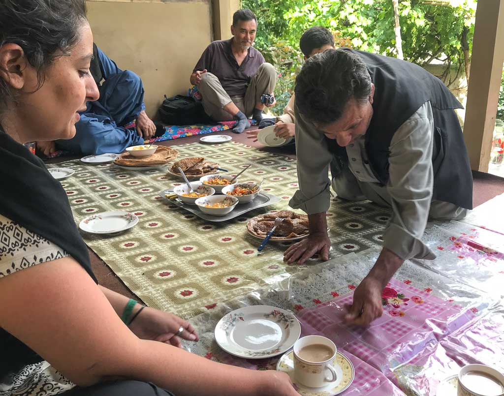
People throughout the region are quite warm and welcoming and will invite you to stay in their homes and even offer you meals. You can try to leave a small amount of money for them as a thank-you, although it is common for them to refuse (I typically try to hide the money somewhere, like under a cushion).

Pakistan is home to over 60 languages, with Urdu and English being the official languages of the country. Gilgit-Baltistan is a clash of cultures and languages. Languages spoken in the region include Shina, Balti, Burushaski, Khowar, Wakhi, Domaki, Gujari, Pashto, Ladakhi, Zangskari, and Purgi.
The population of Gilgit-Baltistan are Muslim with the majority being of the Shia Sect, although the region is fairly diverse. You will find practitioners of both Sunni and Shia sects as well as Ismailism.
What To Wear In Gilgit-Baltistan
I 100% recommend purchasing a shalwar kameez when you arrive in Gilgit-Baltistan or Pakistan in general. Why wear something uncomfortable when you can don a shalwar? You can pick up a ready made shalwar for 1,500-2,500 PKR in Gilgit, but if you have the time I recommend having one tailored.
Okay, so what if you don’t want to wear the shalwar…
For The Boys : Trousers and long sleeve tops, but t-shirts are acceptable.
For The Girls : It’s best to dress conservatively because it’s the norm in Gilgit-Baltistan Long sleeved tunics that go mid-thigh in length or longer are best worn with trousers. Always have a scarf with you although you won’t be expected to wear it covering your hair most of the time.

Best Time To Visit Gilgit-Baltistan
For trekking and camping, the best time to visit is June-August, however, August can get quite crowded and a bit more expensive with Pakistani tourists visiting as well from all over the country. October & November are a great time to visit with the beautiful fall colors underway.
Getting Around
Most traveling in Gilgit-Baltistan will be done by either bus or jeep hire. NATCO (Northern Area Transport Corporation) is the most well-known transport company is in the area, but there are others. Transport companies, as well as tour operators in the region, can arrange jeep hire as well.

How To Get To Gilgit-Baltistan
To reach Gilgit-Baltistan you can do so by air and by road.
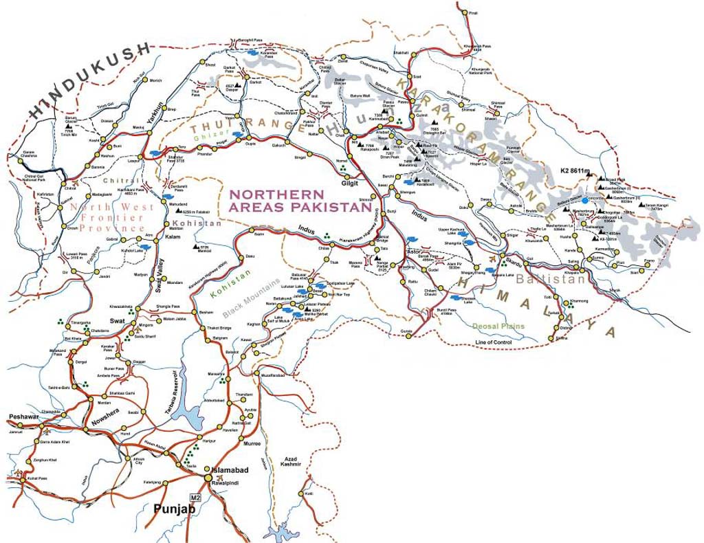
The Karakoram Highway (Aka: KKH or N-35) connects Gilgit-Baltistan with China to the north and to Islamabad in the south.
For those coming from Islamabad/Rawalpindi by bus, the journey to Gilgit will take roughly 19 hours and costs between 1,600 and 2,300 PKR.
For those coming down the KKH from China expect the journey (once the bus actually leaves) to take about 6 hours from Tashkurgan to the Pakistani border post at Sost. You can book buses either with NATCO or Hunza Xinjiang Trading & Tourism from the bus station in Tashkurgan for 225 RMB ($33 USD).
You will need to clear Chinese customs and immigration in Tashkurgan before boarding your bus (which will leave from the Khunjerab Port where you clear customs/immigration). From there it’s about 3 hours to the actual border crossing fence to Pakistan. From the fence expect about 3 hours of travel time to arrive in Sost.
From Sost you can find buses bound for the Hunza Valley, Gilgit, Skardu, Chilas, Astore, and beyond.
Read: Everything you need to know to cross the border at Khunjerab Pass
One thing to note is that you will have to get out and pay the Khunjerab National Park fee on the way to Sost. You can pay the fee in Pakistani Rupee (800 PKR), Chinese Yuan (50 RMB), or US Dollars ($8 USD).
Pakistan International Airlines (PIA) offers daily flights to Gilgit from Islamabad, taking about 50 minutes. It’s known to be one of the most scenic flights in the world but is prone to delays and cancellations due to weather. Prices are 12,110 PKR each way (roughly $100 USD).
PIA also offers a daily flight to Skardu from Islamabad taking 1 hour. This flight is scenic as well and suffers weather delays much like the Gilgit flight. Prices are 15,420 PKR each way (about $125 USD).
Many visitors are now eligible for an e-visa to visit Pakistan. You can apply for yours here .
I will mention that in 2019 I applied and paid for a one-year multi-entry in my Italian passport and only received a single entry e-visa (I enquired about the mistake but it has never been resolved), so I’ve paid $52 for a single entry visa, rather than the $35 fee that you would normally pay for a single entry- so consider yourself warned.

In 2018 I still had to apply the old-fashioned way, through a consulate (this was on my US passport). I can say from personal experience that obtaining a tourist visa from the Pakistani Consulate in Los Angeles was simple, fast, and straightforward. The only document I was asked for that was not mentioned in the instructions on their website was a letter from my employer stating that my travel in Pakistan was not work-related and that I would be returning to my job after my trip.
Note that the visa application, whether applying online or at the consulate is extremely long and full of plenty of questions that I think are pointless (like seriously? I have to list every place I’ve visited in the last 5 years?!!?)

Permits & Special Permissions
You may have read in Pakistan you may need special permissions to visit certain areas and about needing a NOC (no objection certificate) to visit certain places. Most places that tourists go to in Gilgit-Baltistan do not need permits or NOC at the moment. Just note that anything in regards to bureaucracy in Pakistan could change in a second without any notice.
Good places to look up conversations on current info or ask questions are The Karakoram Club and Backpacking Pakistan on Facebook. In 2019 there were a lot of talks of certain areas of Pakistan not requiring NOC to visit, but some tourists have been asked for them.
Gilgit-Baltistan cuisine shares a lot in common with Chitrali cuisine in neighboring Khyber-Pakktunkhwa. Of course you will find pilafs, daal and other dishes common throughout Pakistan. Here are a few local dishes you’ll likely find in Gilgit-Baltistan:

Gholmandi : A filling of locally made cheese, coriander, and chives between two buttery chapatis. This is my absolute favorite.
Chapshuru : Meat, onion, chili, tomatoes, and coriander inside a thin dough. It looks similar to a calzone.
Shisar : A fried pastry-like snack made of wheat flour mixed with egg. Similar to fry bread or langos.
Rishoki : Like a pancake or crepe made of egg and wheat flour, dipped in butter. Can be savory or sweet.
Guli : Flatbread of wheat flour covered in heaps of butter.
Mantu : Steamed dumplings usually filled with meat, onion, garlic, and peppers.
Local Fruits : You can buy fresh local fruits ( during the season of course) from people on the side of the road. Make sure and try the mulberries, apricots, cherries, plums, and grapes when in season.
Chai : Chai accompanies every meal, and also be ready for plenty of chai stops in your travels as well.
Accommodation
For those wanting to stay on a tighter budget, it’s recommended to try to stay at smaller hotels, guesthouses, and inns in Gilgit-Baltistan. There are guesthouses and hotels available in Gilgit, Gulmit, Hunza, Karimabad, Fairy Meadows, Skardu, Passu, Astore, and more. Search guesthouses and hotels on booking .
What To See & Do In Gilgit-Baltistan
For those that love dramatic mountains, turquoise glacial lakes, fascinating culture and great trekking Gilgit-Baltistan is a true paradise. There are too many stunning places to mention to check out here for this one blog post! Here are a few of the most common draws for those who visit the region.
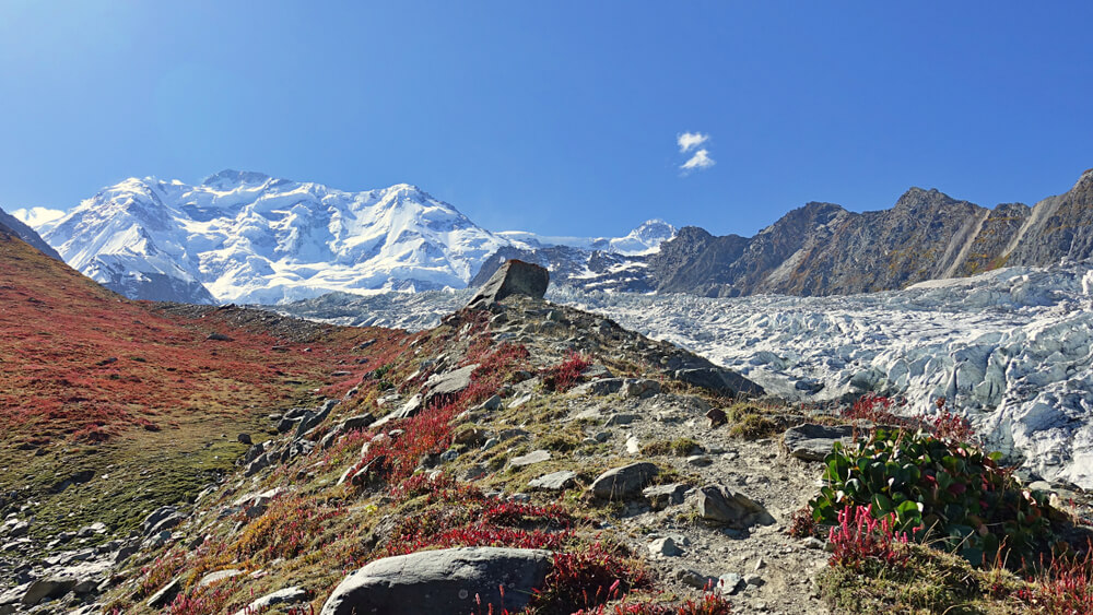
K2 Basecamp, Baltoro & Concordia Glacier – The trek that takes you to the basecamp of the world’s second-highest peak. Usually an 18-19 day trek roundtrip.
Passu Cones – The Passu Cones can be seen as you traverse the Karakoram Highway in the Upper Hunza Valley near the village and glacier of the same name.
Hussaini Bridge – Known as the most dangerous bridge in the world. This rickety suspension bridge crosses the Hunza River with views of the Passu Cones in the distance.
Attabad Lake – This massive glacial lake was only formed in 2010 by a landslide that blocked the flow of the Hunza River resulting in this turquoise lake. The lake destroyed a section of the Karakoram Highway, forcing vehicular traffic to use barges to traverse the damaged 24 kilometer stretch. In 2015 the KKH was reopened through this section after 3 years of work and several tunnels and bridges. Attabad lake is 21 kilometers in length.
Baltit & Altit Forts – These 700 year old and 1,000 year old ( respectively ) forts perched in the Hunza Valley were once the homes of the Mir ( king ) of Hunza. They have sweeping views of the peaks and glaciers nearby.
Trekking – There are a dizzying amount of trekking and mountaineering options in Gilgit-Baltistan that will keep everyone happy from beginner to hardcore mountaineer.
Fishing – Until I stepped foot in Northern Pakistan I never knew that trout fishing was a big deal here.
Cycling – Many come to Gilgit-Baltistan to cycle the Karakoram Highway between Islamabad and Kashgar, China.
Where To Go
Gilgit-Baltistan is one of the most beautiful parts of Pakistan known for its massive mountain peaks. If you hate stunning mountain sceneries, sparkling lakes, welcoming people, and great food you probably should have stopped reading this travel guide a long time ago.

Gilgit City : The central travel hub for Gilgit-Baltistan and largest town along the Pakistani KKH. The main reasons to come to Gilgit is to exchange or get money out of an ATM, stock up on supplies/do some shopping, or spend a night between adventures. Gilgit City is accessible by road and plane.
The KKH connects the city with Xinjiang Province and China all the way south to Islamabad. Daily flights connect Gilgit to Islamabad.
Sost : Border town along the KKH in the Upper Hunza (Gojal) Valley. If arriving from China, Sost will be your first stop. Sost is the customs and immigration point for those coming from or heading to China.

Shimshal : Village in the north of Gilgit inhabited by Wakhi people. Several multi-day treks can be done from here including the most well-known in the area to Shimshal Pass. Note that most trekking in the Shimshal area requires prior permission, contact a local tour agency to arrange them.
Hunza & Nagar Valleys : Hunza and Nagar were formerly princely states until 1974. The Hunza Valley is a big draw for tourists to Gilgit-Baltistan.
Nagar Valley is located just south of Hunza Valley as you make your way down the KKH. From the Nagar Valley, you will have amazing views of Rakaposhi- the 27th tallest mountain in the world from the highway.
A few of the places to visit in the valley include:
- Passu Cones & Glacier
- Hussaini Bridge
- Baltit Fort & Karimabad
- Attabad Lake
- Barpu Glacier

Ishkoman Valley : Home to 20 villages that sit along the Ishkoman River at the bottom of the valley that lies between the Hindu Kush to the west and Karakorams to the east. There are several treks that can be done from Ishkoman Valley including a trek up Chillinji Pass to join the Chipursan Valley, and eventually back to the KKH near Sost, a trek connecting Imit to Darkot in Yasin Valley as well as another connecting Chatorkhand with Yasin Valley, and even a trek up the Karumbar Pass taking you to Karumbar Lake near the border with the Wakhan Corridor of Afghanistan . Another trek that can be done from Chatorkhand and Pakora up to Pakora Pass to reach either Nagar or Chalt.
Trekking to Asumber Pass between Asumber Village in Ishkoman Valley and Sandhi Yasin in Yasin Valley is another hike connecting to the two valleys. Another scenic hiking option is to hike from Gotulti in the upper Ishkoman Valley to Attar Lakes, up over Attar Pass to reach Darkhot in the upper Yasin Valley. Ishkoman Valley is accessible by road from the town of Gakhuch.
Guesthouses are available in Ishkoman Valley including the newly opened Royal Guest House Birgal .

Yasin Valley : Just west of the Ishkoman Valley lies Yasin. Yasin has been historically important because it allowed access to Broghil Pass into Afghanistan’s Wakhan Corridor and to Chitral in Pakistan’s Khyber-Pakhtunkhwa Province. Yasin is reachable by road from the town of Gupis.
There are several treks that connect Ishkoman and Yasin Valleys together (see Ishkoman section above for quick descriptions).

Shandur Pass : Shandur Pass is in the far western fringes of Gilgit-Baltistan’s Ghizer District connecting it to Chitral in Khyber-Pakhtunkhwa Province. Shandur Pass is famous as it is home to the Shandur Polo Festival each year held in July. Shandur Polo Festival is the highest polo festival in the world.
Phandar Valley : Located 60 kilometers west of Gupis, Phandar Valley is green, lush and surrounded by mountains. Access to the valley is possible by road from both Gilgit or from Chitral.
Skardu : Skardu is the capital of Baltistan District and the jumping off point for adventures into the Karakoram Mountains. Skardu can be reached by road from Gilgit and Islamabad, as well as by daily flights from Islamabad. Nearby things to do in the Skardu Valley include:
- Kharpocho Fort
- Shangril-La Lake
- Sand Dunes along the Indus River
- Sartpara Lake
Shigar Valley : The gateway to K-2, G-I, G-II, G-III, G-IV, Broad Peak and more massive mountains in the Karakorams. Expeditions and basecamp treks leave from the town of Askole. Reachable by road from Skardu.
Kharmang Valley : Located about 100 kilometers southeast of Skardu by road. Attractions here include:
- Manthokha Waterfall
- Mehdiabad Valley
- Khamosh Waterfall
- Mehdiabad Nala
Khaplu Valley :
The jumping off point for expeditions to Masherbrum Peak, K-7, K-6, Chogolisa and more peaks in the Karakoram. Located about 100 kilometers east of Skardu and accessible by road. There are several lakes to trek to along the Khaplu Valley as well.
Joot (Fairy Meadows) : A beautiful grassland located near the basecamp for Nanga-Parbat’s Rakhiot Face. From Chilas you will continue along the KKH to the Rakhiot Bridge and drive another 12 kilometers to Tato Village. From Tato trek 5 kilometers to Fairy Meadows.
There are lodges available in Fairy Meadows but you can pitch a tent as well.
Trekking & Mountaineering
Gilgit-Baltistan is a paradise for trekkers and climbers. Some common treks in the area are:
- Fairy Meadows & Nanga Parbat Basecamp
- K2 Basecamp, Concordia Glacier & Baltoro Glacier
- Rakaposhi Basecamp
- Borith Lake & Passu Glacier
- Hoper Valley
- Malik Pass in Deosai Plains National Park
- Yasin Spring Festival : This spring festival in the Yasin Valley is held every year typically between the first and second weeks of March celebrating the start of the new year and upcoming spring.
- Nowruz : Persian New Year. Celebrated on the first day of spring (March 20-22, depending on the year).
- Chilam Joshi : This is a Kalash Spring Festival held in the Kalash valleys of Rumbur, Bumburet, and Birir, in the Chitral District of the neighboring province of Khyber-Pakhtunkhwa. Usually held around May 13-16 each year. The objective of the Kalash Spring Festival is for men and women to find spouses. Colorful dresses and beaded necklaces are worn by the Kalash women.
- Shandur Polo Festival : The highest polo tournament in the world, held at Shandur Pass usually on the second weekend in July. In 2019 it will take place July 8-10.
- Harvest Festival : Dates differ village to village but celebrations fall between June 21 and July 12. Celebrates the beginning of harvest.
- Babusar Polo Festival : A freestyle polo tournament held in the Babusar Pass each year in August. Dates can vary.
- Independence Day : Pakistan’s Independence Day. Held August 14.
- Uchal Festival : Another Kalash Festival held August 20-22 celebrating summer harvest in the Kalash Valleys.
- Gilgit-Baltistan Independence Day : Celebration to mark the end of the Dogra Regime. Held on November 1.
- Chawmos : A Kalash festival held around winter solstice (December 7-22). It’s essentially a wild two week long solstice party of feasts, music, dancing, and more.
- Thumushalling Festival : Celebrating the death of the last Buddhist king of Gilgit. Bonfires and dancing are a part of this celebration held mostly in Hunza, Ishkoman, and Gilgit Valleys on December 21.

Tour Operators & Guides
As we were a small group of mostly American passport holders we did have to go through a tour agency to get LOIs to apply for visas in order to visit Pakistan the first time I went. Hindukush Karakoram Tours & Treks took care of us and I can personally recommend them. Murad & Ayub are two of the best guides I’ve gotten to meet in all my travels.
Gilgit-Baltistan Travel Budget
Costs can vary widely in Pakistan depending on your travel style, and whether or not you will be required to book a tour in the country. While some may scrape by on less than 1,850 PKR per day, others may have a budget of 18,500 PKR per day or more. Here are some ideas of costs in the region:
- Hotel room : Expect prices to ring in around 3,500-100,000 PKR per night.
- Guesthouse : You can find dirt cheap rooms as little as 800 PKR per night. Most will range around 1,000-3,000 PKR per night. For those looking to really save on accommodation, you can try Couchsurfing.
- Local Transport : Depends on distance, but most transport should cost between 500 and 1,500 PKR between destinations in Gilgit-Baltistan. For longer journeys ( Islamabad and beyond ) expect prices to be 1,800 to 3,000 PKR.
- Jeep Hire : Expect to pay 6,000-7,000 PKR per day for a jeep and driver.
- Meals : For simple Pakistani meals you can expect to pay 150-200 PKR per meal, more for fancier restaurants.
- National Parks & Historic Sites : 500-800 PKR.
- Guided Tours : Expect most guided tours to cost in the range of $150-200 per day. Of course this typically would include guide, accommodation, meals and transport.

Packing List
- Inreach Explorer+ – A GPS and SOS beacon that can send text messages as well. Garmin offers reasonable monthly rates. Great for those planning to trek in remote areas.
- Solar charger – Keep your gadgets charged when camping and trekking.
- External battery pack – Good for keeping gadgets charged on long bus rides and when the electricity cuts out.
- Backpack – I recommend the Osprey Ariel 65L backpack .
- Daypack – My personal favorite is the Osprey Hikelite Plus.
- 3 Season tent – I use the MSR NX Hubba-Hubba solo tent and the Mountainsmith Morrison 2 person tent and love them both!
- Sleeping bag – Useful for trekkers & cyclists. I use a Nemo sleeping bag cold rated to 20ºF/-7ºC.
- Hiking Boots – My personal favorite is the La Sportiva Nucleo GTX hiking boot.
- Lightweight cooking camp set – For trekkers and cyclists that plan to prepare their own meals.
- Water Purifier – I personally use the Katadyn water filter .
- Trekking Poles – Useful for the steep scree slopes and river crossings you may encounter.
- Headlamp – Useful while camping, and for power outages.
- Sunscreen – Many places you’ll visit in Gilgit-Baltistan are at higher altitudes leaving you more susceptible to sunburn.
- Mosquito Repellant – Recommended in the summertime.
- Prescription & over-the-counter medications .
Guide Books
- Pakistan Traveller – Available in both paperback and digital download.

Online Resources & Handy Apps
- Lost With Purpose : Alex is essentially the queen of solo female travel in Pakistan (I mean, the boys can get pretty much all necessary info from her too).
- Root Network : Led by Alex, Aneeqa, Laila, Sara, and Turfa, the Root Network aims to ensure a sustainable future for the tourism industry of Pakistan.
- The Karakoram Club : Great Facebook group to see photos of the area and meet locals as well as other travelers.
- Backpacking Pakistan : Another good Facebook group. Great resource for Pakistan travel, asking questions, and meeting other travelers.
- Maps.me : Download on your mobile phone. This is an easy to use offline map.
Internet & Mobile
I didn’t come to Gilgit-Baltistan for the internet, and neither should you. Okay, okay, I know sometimes you do need to do important stuff on the internet. Several guesthouses and hotels in towns offer wifi, just be prepared for pretty slow speeds.
For SIM cards the recommended company is Zong, as they have the best coverage in Northern Pakistan- just make sure and have a local sign you up because you’ll pay a lot less.
Health & Safety
- Gilgit-Baltistan is one of the safest parts of Pakistan to visit. Standard precautions are usually enough.
- The most annoying thing you’ll likely encounter is (especially as a woman) are police that decide you need an escort and accompany you to wherever you’re going, even though it’s a perfectly safe place to visit. Of course, if you’re on a tour this won’t be such an issue, but if you’re traveling independently– you’ve been warned. This is probably the most frequent complaint I see from travelers in Pakistan in general.
- Solo female travelers will likely need to a bit more cautious traveling around Pakistan. It is still a very male-dominated society, so you can expect some harassment (though, northern Pakistan seems to be a bit more relaxed about this than other parts of the country). I have spoken with one woman who not once, but twice had men break into her hotel room while she was sleeping in Hunza, presumably to sexually assault her. I’m not trying to scare solo female travelers off, I have many great male and female friends in Pakistan, but these are all things I think you should be aware of.
- Many treks are in remote areas, so do take caution to avoid injury.
- On occasion, there are terroristic attacks that take place in Gilgit-Baltistan (such as the attack on 12 girls’ schools in the Chilas area on August 3 , as well as the attack on mountaineers in Fairy Meadows in 2013 ). They are not the norm in this part of Pakistan but are something to be aware of.
Other Important Notes
- Tourists aren’t allowed near the LOC (line of control) where Gilgit-Baltistan borders Kashmir.
- Sometimes you will find yourself assigned a free police escort armed with an AK-47. Annoying yes- but this isn’t too unusual.
- There are heaps of security checkpoints in Giglit-Baltistan as well as the rest of Pakistan. However, I didn’t find them to be as big a pain in the ass as the ones in Xinjiang, China.
- Bring tons of passport copies and visa copies for above mentioned security checkpoints.
More Posts from Pakistan:

A Simple Guide To Central Asia Visas

The Best Road Trips In The World
Crossing Khunjerab Pass Between Pakistan & China

Gilgit Baltistan Travel Guide: Travel Pakistan’s Northern Areas

A Beginner’s Guide To Central Asia Travel: Discover The Silk Road

12 Stunning Photos From Pakistan’s Gilgit Baltistan

Pakistan Tour: Chawmos Festival, Bazaar Towns & Vibrant Lahore

Travel with Me to China, Tajikistan and Pakistan in 2018!
15 thoughts on “gilgit baltistan travel guide: travel pakistan’s northern areas”.
Hi – I really enjoyed reading your article on Gilgit Baltistan and really felling proud at the same moment. I actually belongs to Gilgit Baltistan Pakistan.
So someone coming from any other place and liked your region and wrote on it to show the world, that is something I said priceless. Once again thank you for showing the real beauty of the GB to the world.
Impressive! Thanks for sharing this.
Good read. Gilgit is really a GEM to visit
Gilgit Baltistan is the crown of Pakistan and the most wanted tourist spot all over the country. Its people are welcoming and pay a lot of respect to the tourists. Thanks for sharing the positive side of Pakistan. I have also written some reasons to visit Pakistan, please read at About Pakistan
I’m not one of those readers that comments on articles often, but yours really compelled me. I hope you continue this. Thanks for sharing the details about Gilgit-Baltistan Travel Guide. For more details visit us at; https://www.facebook.com/Sufitravellers/
Gilgit-Baltistan is famous for its dramatic mountains especially the snow-capped mountains. GB has unlimited scenery views and is known as heaven on earth. It is one of the beautiful places in Pakistan, delighting and pleasing several tourists, travelers, and adventure lovers. Planning to visit Gilgit-Baltistan? Here are the most enchanting places to visit.
THis Gilgit Baltistan travel guide is impressive.
Tangir and Darel are Most beautiful valleys in Gilgit Baltistan
Beautiful pictures of Pakistan, I must say
You guys should try the off-beaten track in Pakistan like this Mukshpuri Top Hike in Winters https://www.how2havefun.com/travel/mukshpuri-track/
What do you think?
Gilgit Baltistan is indeed a heaven on earth
I couldn’t agree more!
nice article, thanks for sharing. keep it up
Thank you!!
Hi, great guide- I suspect you are going to be instrumental in my next trip. I used so much of your advice when I went to Tajikistan and Kyrgyzstan this year. Thanks so much Gill
Hey Gill, Glad it helped you in TJ & KG, I hope you had an amazing time! Where to next year (I’m guessing PK is on the list ?)? I’ll be getting more guides on UZ and AFG out hopefully in the next couple months.
Leave a Comment Cancel Reply
Your email address will not be published. Required fields are marked *
Notify me of followup comments via e-mail. You can also subscribe without commenting.
This site uses Akismet to reduce spam. Learn how your comment data is processed .
Gilgit Baltistan
Among many other beautiful areas, Gilgit Baltistan is the northernmost area in Pakistan, rich in scenic beauty and culture. It has an autonomous status in Pakistan, and its people have a unique culture and traditions, which outsiders love!
For those who don’t know that Gilgit has semi-provincial status, let me tell you its administratively divided into three divisions; Baltistan, Gilgit, and Diamer. And each division is then divided into several districts. The area of Gilgit Baltistan is about 72,971 sq km.
The people here are very hospitable, and you will find a majority of Shia Muslims with a substantial number of Sunni Muslims, Ismaili, Hindus, and Christians. Gilgit Baltistan is also home to many tourist attractions, such as Shandur Pass and Jaglot .
Talking about the climate, it has an extreme continental climate with long, cold winters and short, cool summers.

This place is full of natural beauty, and there are plenty of places you can visit here, like Skardu, Deosai National Park, Karimabad, etc.
If you are planning to visit Gilgit Baltistan, then make sure to pack some warm clothes as the temperature can go below freezing point during winter.
Gilgit Baltistan is a unique region to explore, with a unique language and many activities to enjoy; you’ll be amazed by the beauty of this place!
So, if you want a place to enjoy peace and tranquility, then Gilgit Baltistan is the perfect place for you!
History of Gilgit Baltistan
This region, known as Gilgit Baltistan, was formerly named Federally Administered Northern Areas (FANA). It’s the northernmost political entity within Pakistan and has a very detailed history which you’ll be excited to learn about.
The region has been occupied by various empires and dynasties throughout its history. Before its independence, the area of Gilgit Baltistan was once a part of Jammu and Kashmir, a princely state of India.
Due to rivalry, India doesn’t recognize it as a part of Pakistan and still classifies it as a part of Jammu Kashmir. It has increased the already existing conflict between the two countries.
The territory of the currently called Gilgit was recognized as a separate administrative unit in 1970. The name was “Northern Areas,” and the area at that time included the Baltistan district, other princely states like Hunza and Nagar, and Gilgit Agency.

In 2008, this area was renamed Gilgit Baltistan and was given autonomy. The limited autonomy resulted from the self-governance order signed by the former president of Pakistan, Asif Ali Zardari.
Gilgit has been an important trading area for centuries because of its situation on the silk route. The region’s population is 1.249 million, and the capital is Gilgit.
The official languages of Gilgit Baltistan are English, Urdu, Balti, Shina, and Wakhi. However, many other local languages are spoken in different parts of the region.
Gilgit Baltistan Weather
The climate of Gilgit-Baltistan varies from region to region; you’ll experience the different intensities of cold in various areas of Gilgit.
The massive mountain ranges in Gilgit are one reason there are sharp variations in the weather. The eastern part of the region is moist because of the western Himalayas. However, areas near Karakorum and Hindukush face quite a drier climate.

Spring season starts in April and lasts until the third week of June, and the maximum temperature is between 10 and 20 degrees Celsius.
The summer stays until the end of August, and the fall season begins at the end of October. Then, from November to March, there’s the winter season, during which the temperature can drop to -4 degrees Celsius, bone-freezing.
Capital of Gilgit Baltistan
The capital of Gilgit Baltistan is Gilgit. It is the largest city in the region and serves as the base camp for many tourists because of its strategic location.
It is a beautiful city with plenty of things to do and see. The people are friendly and welcoming, and there are plenty of tourist attractions.
There are several places to visit in Gilgit Baltistan, and it is truly a paradise for nature lovers and adventure seekers.

Gilgit once served as a major center for Buddhism and was an important place on the ancient silk road. Currently, it’s a major junction along the Karakorum highway , which connects Pakistan to China.
The area is gaining popularity in tourism with each passing day, and the things adventurers love to do here are trekking and mountaineering in the Karakorum. This city’s economy depends on agriculture; wheat, maize, and barley are the majorly produced crops.
Gilgit Baltistan Area
Gilgit Baltistan covers an area of 72,971 square kilometers. It is a mountainous region and is home to some of the tallest mountains in the world, like K2, Nanga Parbat, and Rakaposhi.
This region has 14 districts and three divisions, the largest city being Skardu.
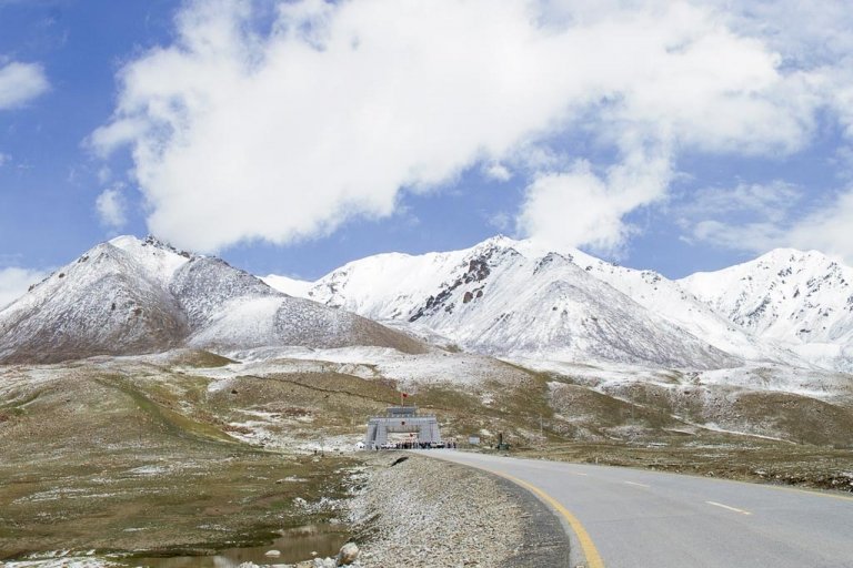
The region is also home to the world’s highest mountain pass, the Khunjerab Pass, which connects Gilgit Baltistan with Xinjiang in China.

Gilgit Baltistan has a population of 1.249 million, per the statistics 2013. The territory of Gilgit-Baltistan is five times more than the area of Azad Kashmir, pretty much massive enough to include lots of beautiful places!
Districts of Gilgit Baltistan
Gilgit Baltistan is a vast region with 14 districts in total. These are Gilgit, Astore, Diamer, Darel, Ghanche, Ghizer, Hunza, Nagar, Kharmang, Gupis-Yasin, Shigar, Skardu, Roundu, and Tangir.
Previously there were only seven districts, and the number rose to 10 in 2016 when the two districts got added into Baltistan valley and the Hunza-Nagar district bifurcated.

The most recent number of these districts is 14 as of 2021. There are three divisions in Gilgit Baltistan; 5 districts are in the Baltistan division, 5 in the Gilgit division, and 4 in the Diamer division.
Gilgit Baltistan is a landlocked region located in the northernmost part of Pakistan. It borders the countries of china and Afghanistan.
Culture and Traditions
Gilgit Baltistan has a fascinating and elegant culture that Pakistani people adore and tourists love to see. The region is ancient, and the culture of people living here is unique and originates somewhere in extreme antiqueness.
Over the years, Gilgit Baltistan has managed to protect the traditions and customs of the people who are the foundation of the cultural life of Gilgit.

The inhabitants of this region are the people of Tibet and Iran. That’s how this region has an amalgamation of different cultures and various patterns of house-making and lifestyles.
The Baltis are very hospitable, offering their guests the best of everything they have. It is a tradition in Baltistan that whenever a guest arrives, he is given the status of God and is treated well.
Tourists who visit attractions like Skardu, Basho, Attabad, and Hunza feel quite amused and are eager to adopt the Gilgit culture during their stay.
What To Pack?
You must wonder what to pack and wear on your trip to Gilgit-Baltistan. But no worries, we’ve got you!
Gilgit is a freezing place, so you need to pack accordingly. You’ll need lots of woolen and thermal clothes to keep yourself warm. But don’t forget to pack some lightweight garments when traveling in summer because it can be hot during the day.
When planning to visit Gilgit Baltistan, one must keep in mind the following packing tips:
– Pack warm but lightweight clothes as you will be doing a lot of walking and hiking.
– A jacket or a couple of sweaters is a must as the evenings can get chilly.
– Do not forget to pack your sunscreen and lip balm.
– A good pair of walking shoes is a must as you will be hiking and trekking.
– A pair of warm pants or jeans is a must, as you’ll have to keep yourself as warm as possible in the winter.
– Make sure you have your gloves and a warm woolen scarf.
– Don’t forget to pack your camera and binoculars to make the most of your trip!
Traveling to Gilgit-Baltistan, you’ll be packing not only clothes and stuff but also a first-aid kit and some emergency medicines that you might need. That’s because the areas you’ll be traveling to are remote, and you won’t be able to find such stuff there.
So make sure you have your travel first-aid kit, emergency motion sickness relief, hand sanitizer, and the covid vaccination certificate.
When to Visit Gilgit Baltistan, Pakistan?
It can be a tricky question when one should visit Gilgit-Baltistan. But no worries, you can see this place any time of year (unless the roads are blocked due to snow in winter). Every single day in Gilgit-Baltistan has its charm and beauty.
It depends on your taste and expectations when you want to come here. First, let’s look at how GB’s different seasons are welcomed.
Spring Season in Gilgit-Baltistan
Spring blossoms in Gilgit begin in April and end in May every year. It’s like a sunrise after a long period of darkness in winter.

The combination of different colored flowers and snow-covered mountains is a sight to behold!
Autumn in Gilgit Baltistan
Autumn in Gilgit-Baltistan brings a vibrant and chic color palette as the mountains are covered in bright yellow leaves. It looks like heaven’s scenery which is more picturesque than any other season. The season begins in October and continues till mid of November every year.
Winters in Gilgit Baltistan
This one is the harshest season in Gilgit, with a temperature of about -10 degrees Celsius, but it has its perks. The snow-capped mountains and valleys look ethereal, and the frozen lakes are a sight to behold. One of the most famous valleys is located in Khaplu .
If you’re an adventure seeker, this is the best time to go trekking, climbing, and skiing in the region, as all these activities require a lot of snowfall. It begins in November and extends up to February.
Summers in Gilgit Baltistan
Each season in Gilgit-Baltistan has its specific beauty, as do the summers. In the summer, lush green landscapes and trees are full of freshly grown organic fruits.

But, because of the high temperatures, the waterfalls and lakes are in full swing. So, if you want to beat the heat, head towards these water bodies and enjoy quality time.
Things to Do in Gilgit Baltistan
There’s no shortage of fun and activities when you’re in Gilgit Baltistan; everything you’ll do will be saved in your memories for a lifetime. Let’s take a look at some of the many things you can do in this beautiful place:
Hike to The Utterly Beautiful Mountains
Gilgit-Baltistan offers some of the best hikes in the world. Some peaks and summits provide stunning views, so if you’re a fan of hiking, you’ll be spoilt for choice.

Some of the best hiking trails in Gilgit are Hussaini Bridge -Passu Glacier, Black Glacier Trail, and Rakaposhi Basecamp trail.
Take A Dip in Freezing Lakes
Well, if you’re brave enough and you’ve tried this before, only then can you go for a dip in those cold lakes of Gilgit Baltistan. These lakes are a must-see and a must-try experience.
Go For A Drive Along The Karakoram Highway
One of the most scenic highways in the world, the Karakoram highway is a true delight for anyone who loves road trips. This beautiful highway connects Pakistan to China, one of the most popular tourist attractions in Gilgit Baltistan.
Explore The Skardu Fort
The Skardu Fort or Kharphocho fort is a must-see for anyone visiting Gilgit Baltistan. This fort was built in the 8th century and is an excellent example of ancient architecture.
River Rafting in Skardu or Hunza
If you’re looking for an adrenaline-pumping activity, then river rafting is definitely for you. Skardu and Hunza are two of the best places for river rafting in Gilgit Baltistan.

Spot Some Snow Leopards
If you’re a wildlife enthusiast, you’ll be happy to know that Gilgit Baltistan is home to some of the most majestic animals in the world.
One of these animals is the snow leopard. Snow leopards can be found in the mountainous regions of Gilgit Baltistan. Though it is rare to locate them, some lucky travelers may have sight of snow leopards.
Amenities For Tourists in Gilgit Baltistan
Gilgit Baltistan is a tourist-friendly destination with plenty of amenities for tourists. There are many hotels, resorts, and guest houses in Gilgit Baltistan that cater to the needs of tourists. There are also plenty of restaurants and cafes that serve delicious food. Moreover, many tour operators in Gilgit Baltistan can help tourists plan their trips.
But still, there’s lots of room for improvement as there isn’t much development regarding the infrastructure of tourist sites and the overall tourism industry in Gilgit Baltistan. Nevertheless, Gilgit Baltistan is beautiful, with many things to see and do here.
Places to Visit in Gilgit Baltistan
Pakistan is one of the few countries with a diverse landscape; there’s an abundance of rivers, lakes, glaciers, waterfalls, and springs.
Gilgit Baltistan is a famous spot for tourism in Pakistan and is surrounded by the highest and most significant number of mountains in the world.
Let’s look at what places you must visit when in Gilgit Baltistan.
Skardu at Gilgit Baltistan
Skardu is the largest town in Baltistan and serves as its administrative capital. It’s a place of extreme natural beauty with towering mountains, crystal clear lakes and rivers, glaciers, and verdant green valleys.
It’s in the extreme north of Pakistan and is a connecting point for the paths to the world’s highest mountains like K2, K3, and Gasherbrum.

The people of Skardu are very hospitable, and you’ll find a rich culture and heritage here.
Some places you must visit in Skardu are Shangrila resort, Deosai Plains, and Shigar Fort.
Hunza Valley
On a 3 hours drive from Gilgit, there’s this heavenly mountainous valley of Hunza. It’s home to some spectacular snow-capped mountains, glaciers, and landscapes.
Baltit Fort, Attabad Lake, and Altit Fort are the most popular tourist attractions. People love to visit this place all year, but the best time to visit it lies between May and October.
Hunza valley has three regions, i.e., Upper Hunza Gojal, Lower Hunza, and Central Hunza.
Fairy Meadows at Gilgit Baltistan
Situated at the base of Nanga Parbat, Fairy Meadows is a small village within the Diamer district of Gilgit Baltistan.
The meadows get their name from the numerous fairies in these parts. It is a place of outstanding natural beauty surrounded by towering peaks on all sides.

The best time to visit Fairy Meadows is from June to September when the weather is pleasant and the snow has melted, making it easier to access the village.
This place is only accessible by a 4×4 jeep or on foot and is considered a trekker’s paradise.
K2, also known as Mount Godwin Austen, is the second-highest mountain peak in the world and the tallest in Pakistan. It is located in the Karakoram mountain range of Gilgit Baltistan.
K2 is known as Savage Mountain due to the extreme difficulty of ascent and the high number of fatalities associated with attempts to climb it.
It has an elevation of 28,251 feet (8,611 m) and is a perfect spot to enjoy the view of some of the world’s highest mountains.
Khunjerab Pass at Gilgit Baltistan
The Khunjerab Pass is a high mountain pass on the northern border of Pakistan with China. Its the highest paved international border crossing in the world, with an elevation of 4,693 meters.
It connects the Gilgit Baltistan region in the Pakistani-administered Kashmir with China’s Xinjiang Uyghur Autonomous Region.

Due to its elevation, it’s advisable not to stay at this place for so long, and the best time to visit this spot is during the daytime. Don’t forget to bring warm clothes with you as it can get freezing.
The high-elevation pass has a lot of risks and is a difficult point to reach; you might face altitude sickness, weather concerns, steep road grade, and overall difficulty in getting there.
In the winter season, the pass gets closed from November 30 till May 1, so you have to choose your time accordingly.
Nanga Parbat at Gilgit Baltistan
Nanga Parbat, also known as the “Killer Mountain,” is the ninth-highest mountain peak in the world, with an elevation of 8,126 m. It is located in Gilgit Baltistan, Pakistan, and is part of the western end of the Himalayas.
Nanga Parbat is a rugged mountain to climb and has been nicknamed the “killer mountain” due to the high number of climbers who have died while trying to summit it.
The first successful ascent was not made until 1953; since then, there have been a handful of other successful upgrades.
If you’re looking for a challenge, and are an experienced climber, then Nanga Parbat is worth considering. Just be aware of the risks involved.
Attabad Lake
Attabad lake is another must-see in Gilgit Baltistan; it’s one of the most beautiful lakes in Pakistan. It was formed in 2010 when a landslide blocked the Hunza River, creating a massive lake of over 20 kilometers.
The Attabad Lake is a beautiful turquoise color and is surrounded by mountains. You can take a boat ride or hike in the lake.

Thousands of visitors come to see this lake; thus, it has become one of the most popular tourist destinations in Gilgit Baltistan.
Naltar Valley at Gilgit Baltistan
The Naltar Valley is one of the most picturesque places in Gilgit Baltistan, 34 kilometers from the city of Gilgit. It’s a valley that is home to different colored lakes, as well as mountains and forests.
You can go hiking and camping in the Naltar Valley or take a jeep tour to see the different sights. In addition, the Naltar valley observes an international festival held at Naltar Ski Resort in the winter season.
The most famous lakes in this valley are Satrangi Lake, Dhudia lake, Blue Lake, and Halima Lake.
The Rakaposhi mountain is one of the most popular tourist attractions in Gilgit Baltistan. It is situated in the Nagar Valley and is about 7788 meters high.
You can go trekking to the Rakaposhi, and the best time for this hike is from June to September.
In the local language, “Rakaposhi” means the shining wall. The peak is the 27th highest in the world and the 12th highest in Pakistan, but it’s more famous for its magical beauty.
Minimarg, a scenic village in the Astore district of Gilgit-Baltistan, once served as an ancient route for trade between Gilgit and Srinagar.
The beautiful valley is located close to the ever-famous Deosai plains. This travel destination has gained lots of popularity in recent years because of the views it offers.
You can travel to Minimarg from Skardu through Chilas , which will take almost 6 hours. But the views are worth the effort.
The sunset in this valley is eye-catching, and the nights are colder than you can imagine, but the experience of camping under the stars is heavenly.
Deosai National Park at Gilgit Baltistan
Deosai National Park is one of the highest national parks in the world. It is a land of extremes where one can find some of the rarest animals on Earth. The plateau is located in between Skardu, Astore, and Kharmang valleys.
The park is located in the Himalayan region and is home to the brown bear, ibex, red fox, Tibetan wolf, weasel, and many more.

The best time to visit the park is from mid of June to August, when the Deosai plains are full of wildflowers, and the beauty over there is indescribable.
You can make the most of your visit by exploring the Deosai lakes, alpine meadows, and peaks.
Karimabad at Gilgit Baltistan
Karimabad, formerly Baltit, is a town in Gilgit Baltistan, Pakistan. It is the capital of Hunza Valley. The old town was founded in the 15th century. It is located at an elevation of 8,200 feet.
The town has a population of 16,000 as per the statistics of 1992. The main languages spoken in Karimabad are Burushaski, Wakhi, and Shina. The people of this valley are very hospitable and welcoming.
The main attractions in Karimabad are Baltit Fort, Altit Fort, Lady Finger, Passu Cones, and Rakaposhi.
Lady Finger
The lady finger peak, also known as Bublimotin or Bubli Mutin, is located in Gilgit Baltistan. It is one of the most popular trekking peaks in Pakistan. The elevation is 600 meters high and offers a stunning view of the surrounding mountains.
The Lady finger is an excellent place for rock climbing and mountaineering. It is also a popular destination for photographers and nature lovers.
Pack your bags and head to the lady finger peak for an unforgettable experience.
Passu Cones at Gilgit Baltistan
Passu is a village in Gilgit-Baltistan near Gulmit. The Passu cones are the mountain peaks in the Gilgit Baltistan region of Pakistan and offer a spectacular view from the Karakorum highway. The cones are shaped like cone-shaped mountains and are too steep-shaped that snow can’t sit on their peaks, thus known as hot mountains.

Passu village has always been a great tourist spot because of the gorgeous-looking Passu cones and the massive Passu sar mountain.
Astore Valleyat Gilgit Baltistan
The Astore valley is a beautiful place in the Astore district, Gilgit Baltistan region of Pakistan. The valley is known for its scenic beauty and breathtaking views and is on an elevation of 2600 m above sea level, a perfect spot to spend a day.
The Astore valley is a great place to visit for trekking, hiking, and mountaineering. There are many trails and mountains to explore in the valley.
The valley remains covered in snow from October to April, and the scenes mesmerize.
Rama valley is another treat to the eyes on your trip to Gilgit-Baltistan. It is situated in the Astore district and at an elevation of 3000 m above sea level. The valley is surrounded by high mountains and offers a stunning view of the Nanga Parbat peak.
The Rama lake is also a great attraction that offers stunning views of the mountains in its crystal clear waters and helps the visitors soothe and relax after a long hike.
There are thick pine, Juniper, and cedar forests, and the valley remains snow-clad for most of the year. Rama valley is an ideal place for camping, trekking, and mountaineering and can be a perfect place to spend a day or two on your vacation.
Baltit Fort at Gilgit Baltistan
The Baltit Fort is one of the most popular tourist attractions in Gilgit Baltistan. Located near Karimabad, this fort was built in the 8th century CE and has been on the UNESCO world heritage tentative list since 2004.

The fort has been restored and now houses a museum; it attracts thousands of visitors to Gilgit-Baltistan and has helped the local community regain their faith in their pride.
You can also enjoy stunning views of the city from the fort. It’s a must-visit on every tourist’s bucket list.
The Karakoram mountain range is one of the most popular tourist attractions in Gilgit Baltistan. It is home to some of the world’s highest mountains, including K2, the second-highest mountain.
It’s a part of complex mountain ranges at the center of Asia, including the Hindukush to the west and Pamirs to the northwest. This mountain range has the greatest concentration of the highest mountains and longest glaciers outside the high latitudes.
You can go trekking or mountaineering in the Karakoram range or enjoy the stunning views of the mountains.
Satpara Lake at Gilgit Baltistan
Satpara Lake is a beautiful freshwater lake located in the Skardu district at 2636 meters above sea level.
This beautiful lake is not only a tourist destination but also provides water to Skardu valley and is spread over an area of 2.5 square kilometers.

The lake is surrounded by picturesque mountains and offers stunning views. You can go for a swim, paddle in a boat, or enjoy the scenery.
Altit Fort at Gilgit Baltistan
Altit Fort is one of the oldest fortresses in Gilgit Baltistan. The rulers of Hunza built it in the 11th century.
The fort is located on a hilltop and offers stunning views of the Hunza Valley. You can also see the Altit village from here. Altit fort is another award-winning heritage site that got restored in 2007. Don’t forget to visit it on your trip to Gilgit-Baltistan.
Is Gilgit Baltistan Safe to Travel?
Gilgit Baltistan is a safe place to travel. There are no reports of crime or terrorism, and the people are friendly and welcoming. However, it is always wise to take precautions when traveling to any new place. Be cautious when traveling solo or in remote areas.
What is The Language of Gilgit Baltistan?
The official language of Gilgit Baltistan is Balti because it’s spoken in most parts of Gilgit Baltistan. However, the people also talk in Burushaski and Shina. In addition, most people also understand and speak Urdu.
How to Reach Gilgit Baltistan from Islamabad?
The best way to reach Gilgit Baltistan from Islamabad is by air. There are daily flights from Islamabad to Gilgit.
However, if you’re an adventure lover, you can opt to go by road. Traveling from Islamabad to Gilgit and Skardu is one of the most enjoyable journeys, as you’ll pass through scenic wonderlands and beautiful valleys.
There are two routes to travel by road from Islamabad to Gilgit Baltistan.
1) The first and most popular route is via the Karakoram Highway, also known as the friendship highway. It is the world’s highest paved international road which connects Pakistan with China. The journey from Islamabad to Gilgit Baltistan takes approximately 22 hours.
2) The second route is from Islamabad to Mansehra city of KPK, but from this route, you’ll be following a national highway named N15. You’ll pass through scenic spots like Naran, Kaghan valleys, and Babusar top of Gilgit-Baltistan.
Top Hotels To Stay
There are many top hotels in Gilgit Baltistan, depending on your budget and preferences. Some of the most popular hotels are:
1. Serena Shigar Fort Hotel
2. Luxus Hunza Attabad Lake Resort
3. Gilgit Serena Hotel
4. Fairyland Hotel
5. Riverdale Resort Gilgit
6. Duroyou Inn
These hotels are known for their top-notch facilities and luxury services. However, many mid-range and budget hotels are also available if you are looking for more affordable options. Therefore, you can easily find a hotel that suits your needs and budget.
Gilgit To Skardu Distance
The distance from Gilgit to Skardu is about 200 kilometers. The journey takes around 4-5 hours by road. You can also take a flight from Gilgit to Skardu, which takes about 50 minutes. Many flights are operating between these two cities.
Frequently Asked Questions
When Did Gilgit-Baltistan Get Independence?
The Independence Day of Gilgit-Baltistan is marked on November 1 every year. That was the day when the Gilgit Scouts got liberated their homeland from the Dogra Raj in 1947. But, unfortunately, they arrested Dogra Governor Ghansara Singh as well.
What is The Population of Gilgit?
The population of Gilgit is about 1.249 million, as per the calculations of 2013. The majority of the population is Shia Muslim.
Can You Visit Gilgit in Winter?
Yes, you can visit Gilgit in winter. The weather is cold in Gilgit during winter, but it is still possible to travel around and explore the city. However, you should pack warm clothes if you visit Gilgit in winter.
What is The Main City of Gilgit-Baltistan?
The main city of Gilgit-Baltistan is Gilgit. It is the region’s capital and the largest city in terms of population. Gilgit is a beautiful city located in the foothills of the Himalayas.
Does Gilgit Have Snow?
Yes, Gilgit has snow. The city experiences heavy snowfall during winter. That can make travel difficult, so it is essential to be prepared if you are planning to visit Gilgit during this time. Pack warm clothes, and have your winter tires on your vehicle.
Gilgit Baltistan, Pakistan, is a beautiful and culturally rich region of Pakistan. There are many places to visit and things to see in Gilgit Baltistan.
You can plan your trip to cover most of the sites in Gilgit because you’ll crave more when you see that place. So make sure to enjoy your trip.
Happy travels!
Individual Posts

Nanga Parbat – The Killer Mountain

Naltar Valley – A Scenic Valley in Pakistan

Khaplu – Tourist Destination in Northern Pakistan

K2 – The Second Highest Peak in The World

Hussaini Bridge – A Famous Yet Dangerous Bridge in Pakistan

Karakoram Highway – An Overview of The National Highway 35

Fairy Meadows – One of The Best Tourist Destination in Pakistan

Chilas – An Overview of Chilas Valley Pakistan

Shandur Pass – The Breathtaking Views from Shandur Top

Jaglot – Gateway of Gilgit and Skardu
Account Options
- 1 Understand
- 3 Get around
- 9.1 Splurge
- 11 Stay safe

Gilgit ( Urdu : گلگت) is a mountain town in the Gilgit-Baltistan region. Travelers exploring the Pakistani Himalayas or en route to or from China are almost definitely going to spend at least one night here. This makes it a great base to further research your trip, meet up with potential travel partners, or simply take a break. It's also a launching pad for climbers to nearby Rakaposhi.
The best season to visit is from May to mid October. The local dialect is Shina, however, Urdu and English are also spoken and understood.

Gilgit is just off the Karakoram Highway between Chilas and Karimabad , and most people arrive by road. The main bus stand is on the KKH - Karakoram Highway , and requires a taxi ride or shared jeep to reach from town. There are booking agents in town for long distance buses along the KKH. The journey from Islamabad can take as long as 24 hours, costs between Rs.3020 and Rs.4180 and departs three times a day from the Pirwadhai Bus Terminal in Rawalpindi. The official government bus company (which also allows foreigners for passengers) operating between Islamabad/Rawalpindi to Gilgit is NATCO (Northern Areas Transport Corporation) . For foreign passengers on the NATCO bus journey from Islamabad/Rawalpindi to Gilgit it is advised to bring 10 passport copies for the bus driver, which they need to present at every police checkpoint on the highway.
Gilgit has a small airport with scheduled fights from Islamabad with PIA , taking just 45 minutes. Delays and cancellations are however quite frequent due to severe weather.
Private vehicles are normally used as local transport. Renting jeeps is also a common way of moving around. You can go to nearby cities on buses and by air.

- 35.90117 74.39075 1 Gilgit Bridge . The bridge over the fast flowing Gilgit River, at the end of its traditional bazaar, is the largest suspension bridge in Asia (182 metres long and 2 metres wide) permitting enough room for one jeep ata time to cross. ( updated Feb 2015 )
- 35.910816 74.261696 2 Kargah Buddha ( Located on a rock near Kargah Nullah (ravine), 10 km. from Gilgit town ). A beautiful rock engraving of Buddha from 7th century A.D. ( updated Feb 2015 )
- Monument of Taj Mughal : A victory monument of Taj Mughal, built 700 years ago, is 30 km. jeep drive from Gilgit town.
- 36.0839 74.0538 3 Sher Qilla ( 38 km. from Gilgit ). Trekking route links with Naltar valley. Trout fishing can be enjoyed in Sher Qilla Nullah and a small lake. ( updated Feb 2015 )
- Singal : About 61 km from Gilgit - Trekking route links with Chilas and Kohistan valley.
- Gahkuch : Headquarter of Ghizer District - Ideal place for trekking, good fishing sports and duck shooting in season. It is the gateway to Iskoman Valley. Government rest house and private hotels are available (73 km from Gilgit). Archaeological sites in village and a near by village Hatoon.
- 36.1638 74.1798 4 Naltar Valley ( Two hours jeep drive from Gilgit link road ). Government Rest house, private hotels and a ski slope, lush green Alpine forest with small lakes and glaciers, trout fishing in lake. Trekking routes link with Iskoman, Chalt and Punial valley. You can see the statue of Buddha in Kargah . Visit to Chilyli Kargah. ( updated Feb 2015 )
- You can visit by jeep to Ghizar district, Chilass city, Astor district, Hunza Valley , Skardu city and Ghanchy from Gilgit. K2 , at 8,611 meters the world's 2nd Highest peak, Mashaburam, Gashaburam, Rakaposhi and Nanga Parbat (killer mountain) world's 6th highest peak. You can also visit Fairy meadows
This area is no doubt a heaven for trackers and hikers.
- Karakoram Air Safari : PIA offers an amazing air journey.
- Mountaineering, Trekking and Hiking : The area is ideal for mountaineering, trekking and hiking. Permission for mountaineering and trekking for restricted zone is issued by the Ministry of Tourism, Government of Pakistan, Pakistan Sports Complex, Kashmir Highway, Aabpara, Islamabad (Telephone: 92-51-9203509).
- Fishing : Fishing permits are issued by the Fisheries Department and you can enjoy the famous Trouts from Icy water of the region- best of the delicacies.
- Flora & Fauna : If you are interested in CHERRY BLOSSOMS then this is the right place to visit. The valley turns into different shades of pinks in spring starting March to April. It can be compared with cheery blossom festive cities of Japan without any doubt. Apart from them this place is abundant in roses, lilies, pansies, willow, pine and fir trees. Trees of apples, apricots, peaches, plums mulberry, walnuts, persimen and fruits like grapes and pomegranate are seen every where from June to October. Almond trees are a watch to delight - blossming in white and baby pink shades depending on sweet or bitter almond types to a lush green tree- in October ~ March is indeed a sight to remember. The area has its rich wild flora and fauna -which is not found in other parts of the country.
- Boating is a possibility in river Gilgit and river Indus. You can try your luck with rafting as well!
- Camping Almost all hotels and Inns allows camping and provide basic facilities as well as security apart from very friendly and hospitable staff - ready to extend you help whenever needed.
- Gliding People visit the area for paragliding. There is a local association for the sport as well.
- Mountain Biking and Cycling . One can enjoy the most exciting and adventurous tracks on the famous Silk Route. Moreover they can enjoy both the history and culture along with Buddhist sites that not many have ever seen before. This route allows you to enter China through Khunjrab. It is the same area which is the reason of spread of Buddhism from India to China and then to Korea and Japan.
- Walking Tours
With the help of a guide or by yourself - area is safe as well as a treat to experience untouched beauty and a rendez-vous with the locals. One of the most hospitable, down-to-earth, modest and loving people.
There are banks around town that change cash and travelers checks. Some shops accept the foreign currency as well. You can buy gem stones, antiques and Chinese goods - anything from silk to electronics.
- 35.92202 74.31178 1 NLI market , NLI rd . Lively bazaar area, closed to motor traffic on certain days. You can purchase supplies or souvenirs such as gem stones. It is also possible to get a local SIM card here, although this will require a copy of your passport and visa.
You can try local fruits like apples, cherries, apricots and a variety of nuts rich in omega 5 like almonds, chestnuts, walnuts etc. Restaurants offer all sorts of Western breakfast to local ones - like salted tea and bread as well as Chinese food, Tanduries, and local dishes. In this region, people do not eat spicy food like the rest of the country. Local food consists of special baked breads (different varieties), handmade-noodle soups, salted meats, roasted meat, vegetables, fruits & dairy products. All the products are organic as they believe in traditional farming without the use of chemical fertilizers and sprays.

Most of the high end hotels have their own bars but at some areas they have their local alcohol too.

Gilgit has one of the cheapest accommodation for visitors with a budget.
- Park Hotel Gilgit .
- Madina Guest House , NLI Chowk . Popular with foreigners. Has a restaurant with seating area in a courtyard. Prices as of May 2009 are 150 Rs for a 6 bed dorm / 330 Rs for a double with shared bath / 450 Rs for a double w/private bath Rs 200-600 .
- New Tourist Cottage Also popular with foreigners. Private doubles with bath are Rs 320. Rooms are large and well maintained. Also has outdoor seating areas.
- Gilgit Motel .
- Park hotel , Airport Road ( on main road from Jutial to main market ). Quite spacious with good quality food, and best located as antique shops are situated nearby
- 35.92064 74.32902 1 Madina Hotel 2 , Goal Road ( Just north of the airport ), ☏ +923445405504 . Popular with backpackers, has private rooms arranged around a lovely garden courtyard and a small restaurant serving good food. Has a new dorm room (2019) for 800, private rooms for 1500. The owner Mr Yaqoob is very nice. Space for secure parking and Wifi ( updated May 2022 )
- 35.9004 74.3541 2 Gilgit Serena Hotel , Sherullah Baig Road Jutial , ☏ +92 5811 455894 . ( updated Dec 2022 )
There are a handful of internet cafes along the main road. Fax and telex are also available.
The main post office (M-Sa 9AM-7PM, closed Sundays) is at Saddar Bazaar on the main road.
Gilgit is fairly stable and safe compared to other regions. Travelers - both local and foreign still visit the area and enjoy the breathtaking beauty and nature.

- Rakaposhi – this nearby mountain is a popular destination for climbers and hikers, and offers stunning landscapes at most times of the year. The views en route to base camp are especially fantastic in the fall when the surrounding countryside is painted orange yellow and red. You could arrange a tour here in Gilgit, or gather information on hiking around yourself.
- Hunza Valley
You can see Hunza valley right from Gilgit near Diamir area. All the autumn colors and seasonal changes give a sit at home treat. It takes 35 minutes by jeep to get to Hunza but weather and traffic are two important factors leading to a bit longer drive to Hunza. The drive towards Hunza is exciting, breath-taking, and once in a lifetime experience. Hunza has the highest literacy rate of Pakistan, close to 98%. People are very friendly and it is quite developed. UNESCO World Heritage Sites can also be seen there.
- Skardu Valley
- Has custom banner
- Has map markers
- Airport listing
- Has mapframe
- Do listing with no coordinates
- Sleep listing with no coordinates
- Gilgit-Baltistan
- All destination articles
- Outline cities
- Outline articles
- City articles
- Has Geo parameter
- Pages with maps
Navigation menu
- Azad Kashmir
- Balochistan
- Gilgit Baltistan
- Khyber Pakhtunkhwa
- Travel Photography
- Travel Vlogs
- Travel Guides
- Accommodation & Transport
- Dos and Don’ts
- Solo Female Travel
- Travel Safety Tips
- What to Wear

- Traveling To Turkey from Pakistan
- Life Saving Tips for A Winter Road Trip in Pakistan
- Most Popular Places to Visit in Pakistan
- Winter summit on K2 by Nepali Team
- Submit a Guest Post
- Request a Review
- Invite to Your Event
- Collaborate
- Shop Inquiry

Travelers Guide to Gilgit Baltistan
Here is a guide to Gilgit Baltistan, so that you know the basic details before you plan or start your trip.
Gilgit Baltistan is one of the most popular places in Pakistan. It is located in the high altitude mountainous region. Karakoram, Hindu Kuch, and Himalayan ranges meet here. The valleys between the mountains attract all kinds of travelers from across the world.
Where is it Located?
Gilgit Baltistan is a popular tourist destination in Pakistan. The region is most famous for the Karakoram, the Hindukush ranges, and mountains. This region shares borders with China’s Xinjiang region over the Khunjerab Pass in the North, with Kashmir, Khyber Pakhtunkhwa, and the Wakhan Corridor.
How to Get to Gilgit Baltistan?
Flight fly everyday from Islamabad to Gilgit and Skardu. Depending on your itineary you can choose the destination to fly to. There are no flight between Skardu and Gilgit. The fastest route between Gilgit and Skardu by road is approximately 4 and half hour.
The only route to reach Gilgit Baltistan from Islamabad is via the Karakoram Highway. But there are different starting route to take all of which will converge into one at some point.
- Route 1: via Babusar – Naran – Chilas – Gilgit
- Route 2: via Abbotabad – Mansehra – Batgram – Dasu – Chilas – Gilgit
- To Skardu: Continue the above route and leave the Karakorma Highway after Chilas – Jaglot – Skardu
Most people start their trip to Gilgit Baltistan from Gilgit city or Skardu.

Major Cities and Towns
A lot of people travel to Gilgit Baltistan for the Karakoram. Each year people join expeditions to K2 Base Camp, Concordia, Nanga Parbat Basecamp, and Basecamps of numerous other 8000 m and 7000m mountains. Climbing expeditions, rock climbing, and other high altitude mountain activities attract travelers and adventure lovers from around the world. Few of the popular towns in the region:
- Hunza Valley

People of Gilgit Baltistan
People in the region are Muslim belonging to different sects. They are cuturally diverse and belong from different ethnic groups.
Moreover, people of Gilgit Baltistan are warm, kind and known for their hospitality. Since the economy of the region relies on tourism, thus most people treat tourists with respect.
The diverse people of Gilgit Baltistan speak many different languages which include Shina, Domki, Balti, Burushaski, Wakhi, Khowar, among others. But the common language used between people is Urdu. Younger people can understand and talk in English but as one moves towards the remote region fewer people speak English.
Shalwar Kameez is the common everyday attire with addition of long scarf for women, just like all of Pakistan. Headscarfs are not a compulsion for women but mosques and religious places require women to cover head with scarf or dupatta.
As many tourist travel to the region, modest weatern wear including jeans, shirts, track suits, long skirt are all acceptable. Jeans long slevees shirt are common for both men and women. For women showing cleavage, midriff and waist will bring un-needed attention.
Local cuisine in Gilgit Baltistan is different from the popular Pakistani dishes. The food is not spicy and many are based in butter and milk.
Some of the popular dishes include:
- Mamtu (Dumpling)
- Dodo (Noodle soup)
- Harisa (Wheat porridge)
- Tumuru Tea (hearbal tea)
- Kilaow (dryfruits dipped in molasses)
- Giyaling (traditional Pancake)
Guide to Gilgit Baltistan: Activities
After knowing all the regions, next are the things to do! Few popular activities and things to do or plan your trip around are:
- K2 Basecamp trekking
- Easy to difficult long trekking and hiking trips
- Visit the beautiful forts and resorts
- Go on short hikes and treks
- Enjoy glaciers, lakes, and rivers
- Enjoy the unique culture
- Camping and fishing trip
- Visit National Parks
- Drive to the highest border crossing at Khunjerab Pass
- Stay in some of the remotest and excluded areas
- Summit a Mountain. Apart from 7000 m and 8000m famous peaks, there are many 6000 m and 7000 m mountains that don’t require technical skills and can be submitted with expert guides.
Also, check out Things to do in Skardu Valley and Karimabad Hunza Valley

Additionally, local festivals and celebrations in the region are worth mentioning. These local festivals give an insight into the culture of the locals and some of these festivals attract people from across the country. Some annual festivals include:
- Shandur Festival
- Silk route Festival
- Baba Ghundi Festival
- Harvest Festivals
- Mayfang Festival
- Safranga Jeep Rally and Festival
- Local Music Festivals (usually in spring and summers)
Images from different colorful and vibrant festivals.

Buy Karakoram T-shirts!
Guide to Gilgit Baltistan: Accommodation
After you have made your mind to travel, choose the best place to have a comfortable stay. Most of the cities and towns in Gilgit Baltistan have hotels, guest houses, camping sites. Most of these offer meals or have small restaurant setups.
All transport within Gilgit Baltistan is by road. Public transportation includes bus service and local vans and coaches. Cars and off-road vehicles can be hired as well.
Bus stops are very easy to locate and are mostly within the city centers. In summers you might need to call for reservations for Bus services.

For coaches and vans, the seats are filled as people come and the ride will start when the driver thinks that a sufficient number of the seats are filled.
The rent for the vans fluctuates depending on fuel price but it is generally cheap.
Car and hired vehicles cost more but are comfortable and provides the opportunity to go on your own pace and make stops. On some routes, you can only go in jeeps and 4X4 vehicles, for example, the Fairy Meadow and Minimerg. You will have to hire your own jeep and driver.
Where to Buy your SIM?
In Gilgit-Baltistan, Pakistani telecom companies SIM (subscriber identity module) cards will work only in few cities and main towns. SCOM telecom company SIM cards are best to use in Gilgit Baltistan and it will work in remote villages. Mobile 3G and 4G network on SIm at present is still very slow.

Leave a Reply Cancel Reply
Your email address will not be published.
Save my name, email, and website in this browser for the next time I comment.
Subscribe to receive Free Event Invitations & Coupons!
- StumbleUpon
Pin It on Pinterest

The Ultimate Travel Guide to Gilgit-Baltistan: Land of the Mighty Mountains
Nestled in the northernmost region of Pakistan, Gilgit-Baltistan is a breathtakingly beautiful destination where the mighty Karakoram, Hindukush, and Himalayan mountain ranges meet. Together, these ranges form some of the world’s highest mountains, including K-2 and Nanga Parbat, which attract mountain enthusiasts and adventurers from around the globe. These majestic peaks are not only a source of pride for the locals but are also a major contributor to the region’s tourism industry.
Apart from its impressive mountain ranges, Gilgit-Baltistan is also renowned for its natural beauty, cultural heritage, folk music, and delicious cuisine. The region is home to some of the most spectacular landscapes in the world, with deep valleys, crystal-clear lakes, and sprawling glaciers. The locals take great pride in their rich cultural heritage and are happy to share their traditions with visitors. The region is also famous for its traditional music, with instruments such as the rubab, surnai, and ghazhek adding a unique flavor to the local culture. When it comes to food, the region’s cuisine is a delightful mix of local and international flavors, with dishes such as chapshoro, momos, and dam pukhtak being particularly popular.
Gilgit Baltistan has many tourist destinations, attracting millions of visitors annually from within the country and internationally. Some of the most popular tourist destinations include Hunza Valley, Skardu, Gilgit City, Khaplu, and Shigar Valley. Each of these destinations has its unique charm and attractions, ranging from historic forts and palaces to picturesque landscapes and vibrant markets.
In this travel blog, I will provide information and tips that every visitor should consider before planning their trip, such as accommodation options, transportation, and local customs. Whether you are a nature lover, a culture enthusiast, or a foodie, Gilgit-Baltistan has something to offer for everyone, and I hope that this travel guide will help you make the most of your visit to this stunning region.
1. Fairy Meadows
Fairy Meadows is located in the Diamer District of Gilgit-Baltistan. It is a popular camping site and offers stunning views of the nearby Nanga Parbat Mountain. The Killer Nanga Parbat is the world’s ninth-highest mountain; visitors can trek to the mountain’s base camp and experience the stunning views of the surrounding peaks and glaciers. Visitors can hike to the meadow or take a jeep ride through the scenic terrain. The meadow is also home to many species of wildflowers and is a great spot for nature photography.
2 . K2 Base Camp
The K2 base camp trek is a dream adventure for thrill-seekers or outdoor enthusiasts. Located in the heart of the Karakoram Mountains range, this trek offers breathtaking views of some of the world’s highest peaks. The trek takes you through lush green valleys, snow-covered mountain passes, and glacial moraines. As you approach the base camp, you will feel a sense of awe and wonder at the sheer size and beauty of K2.
3 . Basho Meadow
Basho Meadow is a picturesque destination in the Skardu region of Gilgit Baltistan. Its lush green meadows and panoramic views of the surrounding mountains make it a popular spot for adventure seekers and nature enthusiasts. Visitors can enjoy various activities such as hiking, camping, and horse riding while enjoying the area’s natural beauty. The meadow is also home to diverse flora and fauna, making it a haven for wildlife lovers. Whether you’re looking for a peaceful retreat or an action-packed adventure, Basho Meadow is worth a visit
4 . Deosai National Park
Deosai National Park is located in the Skardu and Astore District of Gilgit-Baltistan. It is the second-highest plateau in the world and is known for its beautiful landscape and wildlife. Visitors can see various species of animals, such as the Himalayan brown bear, Himalayan ibex, snow leopard and the majestic view of the Sheosar Lake. The park is also home to many species of birds, such as the golden eagle and Himalayan snowcock.
5 . Sarfaranga Cold Desert
Sarfaranga Cold Desert is the world’s highest cold desert and a stunningly beautiful destination in the Shigar District of Gilgit-Baltistan. Majestic snow-capped mountains surround the vast desert. The desert is known for its unique landscape, which features dunes, rocky outcrops, and barren terrain. Visitors can enjoy camel rides, jeep safaris, and camping under the stars.
6 . Baltoro Glacier
Baltoro Glacier is one of the longest glaciers in the world and is located in the Karakoram Mountains range of Gilgit-Baltistan. Visitors can trek to the glacier and experience the stunning views of the surrounding peaks, such as K2 and Broad Peak. The trek can take several days and requires proper planning and equipment.
7 . Rakaposhi Base Camp
Rakaposhi Base Camp, located in the Nagar District of GB, is a mesmerizing destination for adventure enthusiasts and nature lovers. Located in the heart of the Karakoram range, the base camp offers breathtaking views of the majestic Rakaposhi peak, which stands at a towering height of 7,788 meters. Trekking to the base camp is an unforgettable experience that promises to leave you with memories that will last a lifetime.
8 . Shangrilla and Upper Kachura Lake
Shangrilla is a beautiful resort located in Skardu. It offers breathtaking views of the Karakoram Mountains range, lush green meadows, and a serene lake. The resort is surrounded by Lower Kachura Lake, a crystal-clear water body that adds to the place’s scenic beauty. Visitors can enjoy boating, making it a popular tourist spot.
The Upper Kachura Lake is a must-visit destination for nature lovers. The lake is situated at an altitude of 2,500 meters and is surrounded by dense forests and snow-capped mountains. The blue-green water of the lake is a sight to behold, and visitors can take a boat ride to explore its beauty. The lake is also a popular spot for fishing, and visitors can try catching brown trout.
Overall, Shangrilla and Upper Kachura Lake offer a perfect escape from the hustle and bustle of city life and are a must-visit for anyone traveling to Skardu
9 . Masror Rock
Masoor Rock Skardu is a stunning natural wonder in the Skardu District of Gilgit-Baltistan. It is a massive rock formation that offers breathtaking views of the surrounding landscape. The rock is a popular destination for adventure seekers and rock climbers who come worldwide to challenge themselves on its vertical face. For those who prefer a more leisurely experience, the rock can also be enjoyed from a distance while taking in the beauty of the surrounding area.
10 . Shandur Pass
Shandur Pass is a high mountain pass between the Chitral District of Khyber Pakhtunkhwa and the Ghizer District of Gilgit-Baltistan. It is known for its annual Shandur Polo Festival, held in the summer, and is a great way to experience local culture and sports.
11 . Rainbow Lake
Rainbow Lake in Astor is a stunning destination that offers visitors an unforgettable experience. The lake is in the heart of the Ocala National Forest, surrounded by breathtaking natural beauty. With crystal clear water and various fish species, it is a popular spot for fishing and boating enthusiasts. Additionally, the area around the lake is perfect for hiking and camping, making it a great destination for outdoor lovers
12 . Khunjerab Pass
Khunjerab Pass is a high mountain pass located on the border between Pakistan and China. It is the world’s highest paved international border crossing, known for its stunning scenery and challenging terrain. Visitors can enjoy the stunning views of the surrounding peaks and glaciers and experience the unique culture of the local communities.
13 . Attabad Lake
Attabad Lake is located in the Hunza District of Gilgit-Baltistan. It was formed in 2010 after a landslide blocked the Hunza River. The lake is known for its beautiful turquoise color and is a popular spot for boating and fishing. Visitors can also enjoy the stunning views of the surrounding peaks, such as Passu Cones and glaciers.
14 . Khamush Waterfall
Khamush waterfall, located in the Kharmang district of Gilgit-Baltistan, is a hidden gem waiting to be discovered by adventurous travelers. The waterfall cascades down from a height of 200 feet and offers stunning views of the surrounding mountains and forests. Visitors can enjoy a refreshing swim in the cool, clear water or relax and soak in the area’s natural beauty. With its tranquil atmosphere and picturesque setting, Khamush waterfall is a must-visit destination for nature lovers and thrill-seekers alike
15 . Historical Forts
Gilgit Baltistan is a region rich in history and culture, with many historical forts that offer a glimpse into the past. One of the most famous forts is Baltit Fort, located in the Hunza Valley, which dates back to the 8th century. Another impressive fort is the Altit Fort, also located in the Hunza Valley and dates back to the 11th century. The historic Khaplu Palace, located in the Khaplu Valley, is another must-visit site, with a rich history dating back to the 17th century.
Kharphocho Fort, located in the Skardu Valley, is another popular attraction. Finally, the Shigar Fort, located in the Shigar Valley, is another historical gem that dates back to the 17th century and is now converted into a heritage hotel.
16. Skardu Valley
Skardu is the capital of the Baltistan Division and is located on the banks of the Indus River. It is known for its scenic beauty and adventure sports. Visitors can go trekking, hiking, and mountaineering in the nearby mountains, such as K2 and Broad Peak. They can also explore the historic Kharpocho Fort on a hill overlooking the city and many more stunning places waiting for tourists.
17 . Hunza Valley
The Hunza Valley is one of the region’s most picturesque valleys. It is known for its breathtaking landscapes, crystal-clear rivers, and stunning snow-capped mountains. The valley is also famous for its apricot blossom, which blooms in spring. Visitors can enjoy trekking, hiking, mountaineering in the Hunza Valley and exploring the traditional Baltit and Altit forts.
18. Naltar Valley
The Naltar Valley is located in the Gilgit District of Gilgit-Baltistan. It is known for its scenic beauty and skiing facilities. Snow-capped mountains surround the valley, home to many small lakes. Visitors can enjoy skiing in the winter season and can also go hiking and trekking in the summer season.
19. Kachura Valley
Kachura valley is a stunning destination located in the Gilgit-Baltistan region of Pakistan. The valley is known for its crystal-clear blue waters, beautiful landscapes, and scenic views of the surrounding mountains. Soq Valley of the Kachura is a peaceful place with a soothing vibe. Visitors can enjoy various outdoor activities such as trekking, camping, and boating. The valley is a must-visit destination for nature lovers and adventure enthusiasts.
20. Shigar Valley
Shigar Valley is located in the Baltistan Division of Gilgit-Baltistan. It is known for its historic Shigar Fort, which has now been restored and turned into a hotel where visitors can experience the traditional Balti architecture and culture. The valley is also famous for its fruit orchards and popular for camping and trekking. The valley is also known as the land of mighty mountains, home to four of the fourteen highest peaks in the world, with heights above 8000 meters.
21. Astore Valley
Astore Valley is located in the Diamer Division of Gilgit-Baltistan. It is known for its scenic beauty and is a popular spot for trekking and camping. Visitors can explore the nearby Rama Lake, surrounded by snow-capped mountains, or the Chilam Joshi Festival celebrated in the summer, a great way to experience the local culture. Domel and Minimarg will give you the vibe of heaven on earth.
22. Phander Valley
Phander Valley is located in the Ghizer District of Gilgit-Baltistan. It is known for its beautiful Phander Lake, surrounded by lush green meadows and snow-capped mountains. Visitors can enjoy fishing in the lake, and the valley is also a popular spot for camping and trekking.
23. Nagar Valley
Nagar Valley is a scenic destination located in the Gilgit-Baltistan region. The valley is known for its stunning landscape, pristine lakes, and lush green forests. The valley is a paradise for nature lovers and adventure seekers, offering trekking, camping, and rock-climbing activities. The locals’ vibrant culture and hospitality add to Nagar Valley’s charm.
24. Khaplu Valley
The Khaplu Valley is located in the Ghanche District of Gilgit-Baltistan. The valley is famous for its ancient buildings and monuments, such as the Khaplu Palace, built in the 19th century. Visitors can also explore the Chaqchan Mosque, one of the region’s oldest mosques, and the Khaplu Sailing, a popular picnic spot where you can taste fish foods.
25. Gilgit City
Gilgit City is the administrative center and the capital of the Gilgit-Baltistan region. It is located on the banks of the Gilgit River and is known for its lively bazaars and vibrant culture. Visitors can explore the historic Kargah Buddha, a 7th-century rock carving of Buddha, and the Gilgit Fort, built in the 16th century. The city is also a great base for exploring nearby tourist destinations.
About Author

Wazir Zafar Hassan
The writer is a graduate student of International Relations and writes on various political, tourism, climate change, and other social issues. He can be reached at [email protected].
See author's posts
Save, Preserve, and Conserve.
Effects of Altitude on the Human Body – A Tale from the Mountain Peaks
You may like

KIU’s formative impact catalyzes a series of significant accomplishments: Syed Sibt-e-Hassan’s Success Story

Dr. Adeeba’s Resilience: A Journey of Triumph and Inspiration

Embracing Challenges: Gul Rukhsar’s Remarkable Journey

Humira Karim: A Proud alumnus of Department of Chemistry KIU

Traditional women’s dresses of Gilgit-Baltistan

Shuqa Simple but amazing winter clothing of Gilgit-Baltistan
Your email address will not be published. Required fields are marked *
Save my name, email, and website in this browser for the next time I comment.
Discover the Unparalleled Beauty and Culture of Gilgit-Baltistan
Gilgit Baltistan

Nestled within the northern folds of Pakistan, Gilgit-Baltistan emerges as an awe-inspiring destination, boasting not only majestic landscapes, but also a cultural tapestry woven with threads of history and tradition. In this comprehensive guide, we embark on an immersive journey to uncover the hidden treasures and rich heritage of Gilgit-Baltistan, spotlighting the distinctive features that make this region truly extraordinary.
1. Gilgit-Baltistan: A Geographical Marvel:
Gilgit-Baltistan, positioned at the confluence of the Himalayas and the Karakoram Range, stands as a testament to nature’s grandeur. The region’s iconic peaks, including the second-highest mountain globally, K2 , draw mountaineers and adventure seekers. The Indus River weaves through valleys, creating a stunning mosaic of landscapes. From the vast, snow-capped summits to the verdant valleys below, the geographical splendor of Gilgit-Baltistan is nothing short of breathtaking.

2. Cultural Tapestry of Gilgit-Baltistan:
Diversity in Gilgit-Baltistan extends beyond its landscapes to its people. Various ethnic groups, including Shina, Balti, and Brushaski, coexist harmoniously, each contributing to the vibrant cultural fabric. Cultural festivals such as the Shandoor Polo Festival and Navroz not only showcase traditional practices, but also serve as a communal celebration. The locals, known for their warm hospitality, add a layer of authenticity to the cultural experience, making every interaction a journey into the heart of Gilgit-Baltistan’s identity.
3. Must-Visit Destinations in Gilgit-Baltistan:
Every corner of Gilgit-Baltistan beckons with its unique charm. Hunza Valley, with its ancient forts and breathtaking vistas, offers a glimpse into the region’s history. The cobalt blue Attabad Lake, a result of a natural disaster turned tourist attraction, is a marvel to behold. Skardu , a gateway to serene lakes and valleys, captivates visitors with its pristine beauty. Fairy Meadows, nestled beneath the Nanga Parbat, provides a surreal escape into nature. The vibrant bazaars and historical sites tell tales of a bygone era, creating a seamless blend of past and present.
4. Adventure Tourism in Gilgit-Baltistan:
Gilgit-Baltistan isn’t merely a picturesque destination; it’s an adventure enthusiast’s haven. The region’s challenging terrains beckon trekkers and mountaineers from across the globe, offering the chance to conquer some of the world’s highest peaks. As winter blankets the landscape in snow, skiing and snowboarding enthusiasts find their paradise. The thrill of adventure resonates in every footstep, with the region becoming a playground for those seeking the extraordinary. From the adrenaline-pumping ascent of K2 to the serene trekking trails of Rakaposhi, Gilgit-Baltistan invites adventurers to push their limits amidst nature’s grandeur.

5. Flora and Fauna: The Natural Wealth of Gilgit-Baltistan:
Beyond the towering peaks, Gilgit-Baltistan harbors a wealth of biodiversity. The Deosai National Park, a high-altitude plateau, serves as a sanctuary for the endangered Himalayan brown bear and numerous bird species. Conservation efforts underscore the commitment to preserving this natural treasure. The rolling meadows, alpine flowers, and crystal-clear lakes create an ecosystem that is as delicate as it is resilient. In exploring Gilgit-Baltistan’s natural wealth, one becomes part of the ongoing narrative of conservation and ecological balance.
6. Economic Significance and Development:
Gilgit-Baltistan’s economic landscape is intertwined with its rich natural resources and burgeoning tourism industry. Abundant in minerals and possessing significant hydroelectric potential, the region contributes significantly to Pakistan’s economic development. The growing tourism sector not only invites exploration but also creates avenues for employment and business opportunities. Ongoing infrastructure developments, including improved transportation networks, lay the groundwork for sustainable growth. The delicate dance between progress and preservation is evident, as Gilgit-Baltistan strives for economic prosperity while safeguarding its unique identity and natural wonders.
7. How to Reach Gilgit-Baltistan:
Accessing the mountainous haven of Gilgit-Baltistan requires strategic planning. Travelers can choose to arrive by air, with airports in Gilgit and Skardu offering convenient access points. Alternatively, a road journey through the Karakoram Highway provides a scenic adventure, showcasing the region’s rugged beauty. For those seeking practical information, the road to Gilgit-Baltistan becomes a journey in itself, offering glimpses of local life and breathtaking landscapes. Each mode of transportation becomes a gateway to an adventure waiting to unfold.

8. Local Communities and Sustainable Tourism:
Gilgit-Baltistan’s charm lies not only in its landscapes, but in the warmth of its people. Community-based tourism initiatives empower local residents, providing authentic experiences for visitors. Balancing progress with cultural preservation is a delicate dance, and initiatives focusing on sustainable tourism emphasize the importance of preserving the local way of life amidst the winds of change. From homestays in traditional villages to cultural exchanges with local artisans, sustainable tourism initiatives create a symbiotic relationship between visitors and the communities, ensuring that the magic of Gilgit-Baltistan remains intact for generations to come.
Conclusion:
In conclusion, Gilgit-Baltistan invites the world to explore its wonders. From the towering peaks to the cultural celebrations, every aspect of this region tells a story. As visitors traverse the landscapes and engage with the local communities, they become part of a narrative that goes beyond the ordinary tourist experience. The journey to Gilgit-Baltistan promises not just a physical adventure but an immersion into the soul of a region where nature and culture dance in harmonious celebration. It is a journey that leaves an indelible mark, inviting all to discover the unparalleled beauty and culture of Gilgit-Baltistan.
Exploring the Enchanting Astore Valley: A Paradise in the Himalayas.
Astore Valley is a hidden gem in the Gilgit-Baltistan region of Pakistan, nestled among the majestic foothills of the Himalayas. Known for its beautiful landscape, greenish meadows, snow-capped mountains, glistening glaciers, appealing waterfalls, and pristine rivers, this valley offers a truly enthralling experience for nature lovers and adventurers alike.The Valley is located in the eastern part of the Gilgit-Baltistan region bordering the Indian-administrated Jammu and Kashmir, which covers an area of over 592 square kilometers. It stretches 120 kilometers from east to west and is divided by the peak of Nanga Parbat (8126), dominating the sky with its majestic presence. The Astore River flows through the valley, adding to its spectacular beauty.
In Pakistan’s Gilgit Baltistan, the Astore Valley is a veritable treasure mine of historical beauty. Traders have long maintained commercial contacts between their cities and Kashmir’s markets by travelling the Astore Road. Students and businesspeople wishing to purchase Kashmiri textiles frequently visit Srinagar. Throughout history, tourists from all over the region have visited this area. It also played an important role in the settlement of the Astore Valley, thus creating a community.
Natural Beauty and landscapes.
The beauty of the Astore Valley is unparalleled, with its diverse landscape ranging from lush green meadows to snow-capped peaks. The valley is studded with thick woods, alpine pastures, and colourful wildflowers, creating a picturesque tapestry that leaves visitors in awe. Meandering Rivers such as the Astore and Rattu Rivers add to the valley’s charm, providing a tranquil atmosphere and excellent trout fishing opportunities.
Deosai Plateau (shared plateau with Skardu), Rama Lake, and Rupal Valley are some of the scenic attractions in this vast valley. In addition, Astore is known for its diverse natural attractions and proximity to mountain activities that are unique on the planet.
One of the loveliest spots to visit is Rama Astore. Rama Meadows and Rama Lake are about 10-11 km from Astore. Jeeps to Rama Meadows and Rama Lake take more than an hour’s drive. Rama is regarded as one of Pakistan’s most exquisite grasses, with green grass, mountain trees and shrubs, beautiful lakes and mountain vistas.
Deosai National Park is the highest plateau in northern Pakistan, located between Astore and Skardu Valley. It is often called the “land of giants” because it is believed ghosts and giants inhabit the land. At about 4,000 meters (13,000 feet) above sea level, the Deosai Plateau is one of the highest mountains in the world; with its craggy cliffs, flower-filled meadows, sparkling lakes, and rough hills, this valley is renowned for its stunning beauty. The Deosai Valley is completely blanketed in snow throughout the winter, which makes for a stunning winter scene.
Rupal Valley is renowned for its beautiful landscapes, majestic peaks, and diverse plant life and fauna. The valley stretches a giant distance, beginning from the base of Nanga Parbat and lengthening toward the Astore district. The Rupal River flows through the valley, adding to its natural splendour. The valley gives breathtaking views of Nanga Parbat, the “Killer Mountain.” Its snow-protected peaks and sheer cliffs attract mountaineers and adventurers from around the sector. Rupal Face, one of the three faces of Nanga Parbat, is considered one of the globe’s hardest and most technical mountaineering routes.
This majestic Astore Valley consists of more than a hundred villages that are beautiful tourist attractions in themselves, including Trashing, Chilam, Bubin, Gurikot, Rattu, Kamri, Minimarg, Mirmalik Valley, Rehmanpure Valley, and Burzil Top, are breathtaking places. These are distinct by their spectacular beauty.
Adventure and outdoor activities.
The mountain forest makes it a paradise for trekkers, hikers, and climbers. The area offers a variety of trekking routes, from easy hikes to strenuous expeditions, providing an unforgettable experience for outdoor enthusiasts. Astore is a region acknowledged for its pristine rivers and streams, making it a brilliant vacation spot for trout fishing fanatics. Numerous trout species, including the highly valued Brown Trout and Rainbow Trout, are found in the rivers and streams of Astore. Those fish thrive in the clean waters of the region, making it a great spot for anglers searching for a fishing journey.
Cultural Heritage and local life.
Shina is the prevalent language, while Urdu is the second most frequently verbalized language in Astore. The people of Astore are greatly fond of music and dance and have traditional roots. Shalwar kameez among men is common, while women wear kameez (Kurtani.Peeran.Cheelo), Dopata or Shawl (Phatek, Cheel) . The traditional hat is the most gorgeous kit ladies wear in the Astore. The stunning Iraghi hats with classic silsila stones are the most often worn. Agriculture and livestock are the main sources of income for locals, while many Astore men seek work in the major business cities of Pakistan. Traditional cuisine Chapshuro, Mamtu, Sharadi, Harisa, Sharadi, Sharbat, Goli, Diram, and Bread (chappati) are famous among the people.
Sustainable Tourism
Currently, tourism activists are being duped without proper guidance, and tourists do not know the tourism industry. The local government must create a comprehensive vision and plan not just now but for the next ten or two decades to take tourism in the region to another level . The policies must ensure the engagement of international tourists by showing a soft image of the area.
Tourism’s infrastructure is its bedrock. Without a solid infrastructure, trying to draw in foreign visitors is useless. Facilities and infrastructure should be designed to accommodate various visitors’ kinds. For this purpose, the local government is constructing various projects; the 47 KM-long Gorikot-Shonter road costing Rs7bln will be constructed under PSDP, Gorikot to Shonter 47 KM long road will be constructed for seven billion rupees under the public sector development program, the road from Bubin to Shagharthang is also part of these projects.
Conclusion.
Indeed, the Astore Valley is bestowed with nature’s blessing, from the majestic mountains of the Himalayas to crystal clear rivers from landscapes to glaciers. The beauty of this valley attracts people from all around the globe. Government policies with local communities can promote the flux of tourists to Astore. Social media can also play a vital role in enhancing tourism. The people, especially the youth of Astore, will have to understand that tourism has the potential to act as the backbone.

Waqas Ahmed
The writer is a student of BS International Relations at the University of Sargodha.
15 Best Places to Visit in Skardu

Discover the best places to visit in Skardu, Pakistan. Learn about the stunning landscapes, cultural experiences, and tips on how to make the most of your journey and places to visit in Skardu.
Skardu, located in the Gilgit-Baltistan region of Pakistan, is a remote mountain paradise that offers breathtaking landscapes, unique cultural experiences, and a chance to escape the city life’s hustle and bustle. Surrounded by snow-capped mountains, crystal-clear lakes, and lush green valleys, Skardu is a haven for travelers seeking solitude and adventure.
In this travel blog, we will explore this stunning region’s hidden treasures and provide tips on how to make the most of your journey during your visit to Skardu famous places. Skardu has now become synonymous with Baltistan, representing the whole region.
Getting to Skardu
Skardu is accessible by road and air. The Skardu Airport has direct flights from Islamabad. And from Lahore, Karachi, and other cities during summer. Alternatively, you can travel by road from Rawalpindi/Islamabad, which takes around 16-20 hours. The scenic road trip offers stunning views of the mountains and valleys.
Top 15 Places to visit in Skardu

1. Deosai National Park
Deosai National Park is a breathtakingly beautiful and serene destination situated in the Skardu and Astore districts of Gilgit-Baltistan. Spread over 3,000 square kilometers, it is one of the second-highest plateaus in the world and is often referred to as the “Roof of the World”. The park is home to diverse flora and fauna, including the Himalayan brown bear, snow leopard, and ibex.
Apart from the wildlife, Deosai is also known for its stunning landscapes and panoramic views. The park is also dotted with several freshwater lakes, including the Sheosar Lake, Pakistan’s highest lake. The best time to visit Deosai is during the summer when the weather is pleasant and the wildflowers are in full bloom, painting the entire plateau with vibrant colors. Deosai National Park is a must place to visit Skardu destination for nature enthusiasts and adventure seekers.

2. Shangrilla and Upper Kachura Lake
Nestled in the heart of the Karakoram Mountain range lies the picturesque resort of Shangrilla, one of the most famous places in Skardu, also known as “Heaven on Earth.” The resort’s stunning natural beauty is breathtaking, with majestic mountains, lush green forests, and a crystal-clear lake. Shangrilla truly lives up to its name and is a must-visit destination for anyone seeking to reconnect with nature.
Just a short drive from Shangrilla lies the Upper Kachura Lake, a stunningly beautiful lake that is the region’s hidden gem. Towering mountains surround the lake and offer a peaceful retreat for visitors looking to escape the crowds. Visitors can take a boat ride on the lake, go fishing, or relax on the lake’s shore and take in the beauty of their surroundings. The lake is also home to various bird species, making it a popular spot for birdwatchers. Upper Kachura Lake is a truly magical place that showcases the region’s natural beauty and is a must-visit for anyone traveling to Shangrilla.

3. K2 Base Camp
K2, the second-highest mountain in the world, is a breathtaking destination that attracts adventurers and nature enthusiasts worldwide. The K2 base camp trek is a challenging yet rewarding journey that takes you through some of the most spectacular landscapes in the world. For adventurers, it is the best place to visit in Skardu. As you hike through rugged terrain and climb steep passes, you’ll be rewarded with stunning views of snow-capped peaks, glacial lakes, and deep valleys.
The K2 base camp trek is not for the faint of heart, but for those willing to take on the challenge, it’s an experience of a lifetime. Along the way, you’ll have the opportunity to meet friendly locals, experience the region’s unique culture, and camp under the stars in some of the most beautiful places on Earth. Whether you’re an experienced hiker or just starting, the K2 base camp trek is a must-do for anyone looking for an unforgettable adventure in one of the world’s most spectacular destinations.

4. Basho Meadow
Basho Meadow in Skardu is truly a paradise on Earth. Surrounded by breathtaking views of towering mountains, lush green meadows, and crystal-clear streams, this meadow is a perfect destination for nature lovers. The scenery is simply stunning, and the fresh air will leave you rejuvenated. You can trek around the meadow, explore the nearby forests, or sit and soak in the natural beauty.
The meadow is also home to various flora and fauna, including wildflowers and butterflies. The meadow is carpeted with colorful flowers during the spring and summer, making it a sight to behold. The best time to visit Basho Meadow is from May to September, when the weather is mild, and the sky is clear. If you’re looking for a place to escape the city life’s hustle and bustle, Basho Meadow should be on your list of must-visit destinations.

5. Sarfaranga Cold Desert
Sarfaranga Cold Desert, located in the Shigar district of Gilgit-Baltistan, is a truly mesmerizing travel destination. The vast expanse of the cold desert, surrounded by towering mountains, offers breathtaking views that will leave you spellbound. In shades of orange and brown, the dunes create a dramatic contrast against the snow-capped peaks, making for a stunning sight.
Visitors can also engage in various activities, including dune bashing, quad biking, and horse riding. The serene atmosphere, stunning scenery, and thrilling activities make Sarfaranga Cold Desert a must-visit destination for any travel enthusiast who is traveling to Skardu.

6. Soq Valley, Skardu
The Soq Valley is a hidden gem in Pakistan’s northern region. Surrounded by majestic mountains, the valley offers breathtaking views and a serene atmosphere for travelers seeking an escape from the hustle and bustle of city life. The valley is located in the Upper Kachura region, just a twenty-minute drive on bumpy road from the town. Visitors can also enjoy local cuisine and trout fish at the valley. Overall, the Soq Valley Kachura is a must-visit destination for anyone looking to experience the beauty and tranquility of northern Pakistan also known as one of the best places in Skardu.

7. Tormik Meadow
Tormik Meadow is a beautiful travel destination in Pakistan’s northern region. This stunning meadow is situated at an elevation of 3,700 meters above sea level, surrounded by towering mountains and lush greenery. The area is known for its breathtaking views of the Himalayas and the Karakoram range, which makes it a popular spot for trekking enthusiasts.
Visitors to Tormik Meadow can enjoy various outdoor activities such as hiking, camping, and photography. The meadow is accessible via a steep, winding road providing an exciting journey through the mountains. Upon arrival, visitors are greeted with stunning panoramic views of the surrounding landscape, which are awe-inspiring. That’s why it is in the Best places to visit in Skardu list.

8. Shigar Fort
Shigar Fort, also known as Fong-Khar, is a magnificent 17th-century fort in the town of Shigar in Gilgit-Baltistan. This beautiful fort is a unique blend of Tibetan and Balti architecture and has been beautifully restored to its former glory. It is a must place to visit in Skardu for anyone interested in history, culture, and architecture.

The fort has been converted into a hotel that offers a unique opportunity to experience the royal lifestyle of the Balti rulers. The rooms are decorated with traditional Balti furnishings, and the hotel offers a range of activities such as trekking, mountain biking, and fishing in the nearby rivers. The fort also has a museum that houses a collection of artifacts that provide a glimpse into the rich history and culture of the region, which is why it is the top place to visit in Skardu

9. Mantokha Waterfall
Mantokha waterfall in Kharmang district of Gilgit-Baltistan is a breathtaking natural wonder that are a must-visit for adventure seekers and nature enthusiasts. Mantokha waterfall is in a narrow gorge surrounded by towering mountains covered in lush greenery. The sound of the waterfall echoing off the gorge’s walls creates a soothing melody that is both calming and awe-inspiring. The crystal-clear water cascades down the rocks and mixes with the stream. The surrounding landscape is also ideal for hiking and picnicking, making it an ideal spot for a day trip.

10. Khamush Waterfall
Khamush waterfall, on the other hand, is a relatively lesser-known destination hidden away in a remote Kharmang valley. The cascading waterfalls surrounded by towering mountains create a serene atmosphere perfect for those looking to escape the hustle and bustle of city life. The journey to the waterfall is also a treat, with the lush green valleys and glistening streams providing a scenic backdrop. Overall, both Mantokha and Khamush waterfalls are a must-visit for anyone looking to experience the natural beauty of Pakistan.

11. Khaplu Palace
Khaplu Palace is a beautiful historical monument in Pakistan’s Gilgit-Baltistan region. The palace dates back to the mid-19th century and served as the residence of the local royal family. Today, the palace has been converted into a hotel that offers a unique blend of historic charm and modern amenities. The palace’s architecture is a testament to the region’s rich cultural heritage, with intricate woodwork and carvings adorning its walls and ceilings. The majestic Karakoram Mountain range surrounds the palace, and the view from the palace is simply breathtaking.
Visiting Khaplu Palace is an unforgettable experience that glimpses into Gilgit-Baltistan’s rich history and culture. The palace’s luxurious accommodations and stunning surroundings make it the perfect place for a peaceful and relaxing getaway. Whether you’re interested in exploring the local area or want to relax and soak up the beauty of your surroundings, Khaplu Palace is an ideal destination and the best place to visit in Skardu. With its fascinating history, stunning architecture, and breathtaking views, this palace is a must-visit for anyone traveling to the region.

12. Organic Village, Skardu
Organic Village Skardu is a hidden gem in the heart of Pakistan’s northern areas. This serene and picturesque village offers visitors a unique opportunity to experience life in an organic village, where every aspect of daily life revolves around sustainability and self-sufficiency. The village is surrounded by snow-capped mountains and lush green fields, making it an ideal destination for nature lovers and adventurers.
Visitors to Organic Village Skardu can enjoy the local culture and organic cuisines. The villagers are warm and hospitable, and visitors are always welcomed with open arms. One of the highlights of a visit to Organic Village Skardu is the chance to sample the delicious organic produce grown on-site, including fresh fruits, vegetables, and dairy products. Overall, a visit to Organic Village Skardu is an unforgettable experience that offers a unique glimpse into a way of life that is both sustainable and in harmony with nature. That is why it is the best place in Skardu to visit for nature lovers.

13. The Blind Lake
The serene lake is nestled in a valley surrounded by snow-capped peaks, making it a picturesque destination for adventure seekers and nature lovers. A must place to visit in Skardu. The journey to the lake is quite an adventure, as the road leading up to it is narrow and winding, offering breathtaking views of the surrounding mountains. Once you reach the lake, you can relax and soak in the beauty of the place or take a hike along the rugged terrain to explore the area further. Camping by the lake under the stars is an unforgettable experience that will leave you with memories to last a lifetime.
One of the most striking features of Blind Lake Shigar is its crystal-clear water, which reflects the surrounding mountains and sky, creating a mesmerizing panorama. The lake is also home to various fish species, making it a popular spot for fishing enthusiasts.

14. Kharphocho Fort, Skardu
Kharphocho Fort , located in Skardu, is one of the best places to visit in Skardu is a historical landmark and a must-visit destination for those interested in the region’s rich cultural heritage. The fort stands tall on a cliff overlooking the Skardu town and the Indus River, offering a breathtaking view of the surrounding landscape. The fort was built in the 16th century by Ali Sher Khan Anchan, the ruler of Skardu, and has since served as a strategic location for various rulers and armies. The fort was restored recently and now offers visitors a glimpse into the region’s history and architecture.
Visitors can explore the fort’s various chambers, halls, and watchtowers and learn about its rich history and cultural significance. The fort also offers a stunning panoramic view of the surrounding mountains and Skardu Valley, making it an ideal spot for photography enthusiasts.

15. Katpana Desert
Katpana Desert, located in the picturesque region of Skardu in Gilgit Baltistan, is a must-visit places to visit in Skardu for every traveler. This breathtaking desert uniquely blends barren dunes, rugged mountains, and clear blue skies. The best time to visit Katpana is between May and October when the weather is pleasant and the skies are clear. The local culture is warm and welcoming, and visitors can indulge in traditional Pakistani cuisine and enjoy the hospitality of the locals. The serene silence of the desert, the stunning sunsets, and the starry night sky will leave you mesmerized and make your trip a truly unforgettable experience.
Cultural Experiences in Skardu:
Skardu is home to the Balti people with a rich cultural heritage. You can experience the local culture by visiting the local bazaars, trying local food, and participating in traditional festivals.
Balti Culture:
The Balti people have a unique culture and language. You can learn about their culture by visiting the local villages and interacting with the locals. You can shop Balti traditional things from local bazaars, including traditional dresses, caps, and jewellery items.
Must try Local Food, Balti Cuisine while visiting Skardu:
The Balti cuisine is a fusion of Tibetan and Pakistani flavours. You can try local dishes such as Keser (similar to paratha), Mamtu (steamed dumplings), Balay (noodle soup), Plapu (Balti Pasta made of wheat and walnut paste), and Khurba Skardu bread (a type of bread baked in a traditional oven). Don’t forget to taste local Namkeen Chai. You can also try local fruits such as cherries, apples, and various apricots.
Tips for Traveling to Skardu:
Best time to visit skardu:.
The best time to visit Skardu is from May to September, as the weather is pleasant and the roads are accessible. During the winter, the roads may be closed due to heavy snowfall, so it is best to avoid travelling. If you want to enjoy the Autumn colours, mid-October to November is the perfect time. If you are fond of spring, March and April is the best time to witness blossom’s beauty, such as the eye-captivating cherry blossom.
Packing List for Skardu:
When traveling to Skardu, it is important to pack warm clothes, as the weather can be cold, especially at night. You should also bring comfortable walking shoes, sunscreen, and sunblock, as the sun is quite intense in Skardu due to its height.
Safety Tips for Skardu:
Skardu is a safe place to travel, but it is always important to take precautions. You should carry a first-aid kit, stay hydrated, and avoid eating and drinking dirty stuff. It is also essential to respect the local culture and customs to enjoy the hospitality of the locals.
From the best places to visit in Skaredu to cultural experiences and safety tips, Skardu has something for every traveler. So, pack your bags, and prepare for the adventure of a lifetime!

NATO’s Military Engagements: Understanding Their Political Implications

The Indispensable Role of Gilgit-Baltistan in Making Pakistan’s “New Geo-economics” Work

Shamanism- Religion of Magic and Miracles

- Inspiration
- Destinations
- Places To Stay
- Style & Culture
- Food & Drink
- Wellness & Spas
- News & Advice
- Partnerships
- Traveller's Directory
- Travel Tips
- Competitions
All products are independently selected by our editors. If you buy something, we may earn an affiliate commission.
Navigating Gilgit-Baltistan: an intriguing adventure through one of Pakistan's most historically tumultuous regions
By Sam Dalrymple

We are driving up one of the highest roads in the world, cloaked in shawls. The Karakoram Highway traces the Indus River up the spine of Pakistan , a cultural fissure dividing the Himalayas and the Indic world to the south from the Turkic world to the north. Along the highway are countless lavishly decorated trucks: psychedelic galleries in motion, embellished with a dizzying array of calligraphy, paintings, stickers and delicately carved wooden panels. Our vehicle is more mundane but practical: a beaten-up Land Cruiser, driven by the ever-amiable Riaz Ali, who has a habit of finding the most precarious rocky overhangs to perform his prayers.

I have come to Pakistan to visit the remote and icy land that ancient Chinese geographers called “Tibet of the Apricots”. Now known as Gilgit-Baltistan, it is a place of crumbling palaces and Islamic latticework, home to brown bears and snow leopards, where the Persian and Tibetan worlds collide at 8,200 feet. Every Buddhist town in the Himalayas may use James Hilton’s lost city of Shangri-La as a motif to promote itself, but many Pakistanis claim that it was the author’s visit to the liberal Muslim society of this region that inspired him to write the book in which it appears.
For centuries, deadly mountain passes and the highest concentration of 26,000-foot peaks in the world left Gilgit-Baltistan isolated. Unable to rule it directly, various empires tried to govern the region through local leaders, so that as late as 1936, the Kashmir Times noted that one of the most powerful, the Mir of Hunza, still paid “tribute to four governments: British, Chinese, Russian and Kashmiri”. The result was an extraordinarily rich cultural landscape, where a range of languages and traditions coexisted alongside one another. But it was a fragile coexistence and, a decade later, when India and Pakistan went to war over Kashmir, Hunza and the other chiefdoms were dragged into the dispute. Ruled by the Maharajas of Kashmir until 1947, political instability and several high-altitude wars shut off this region to outsiders for decades. The doors to this lost world have only recently been thrown open once again. I wanted to see it for myself.

We cross the jade-coloured Hunza River and enter a bucolic valley where the crisp air is scented with jasmine blossom. Until the 1970s, Karimabad, Hunza’s capital, was still a medieval walled city, but it has since sprawled into perhaps Pakistan’s only tourist town, selling carpets, pashmina, and, true to the epithet, 60 types of apricot. Nonetheless, accustomed to the deforested industrial hill stations of India, with their vast real-estate projects and choked roads, Karimabad feels virtually untouched. In all directions, poplar trees rise from terraced fields and timber-framed houses are still more popular than concrete ones. Towering over the town is Rakaposhi, the 27th tallest mountain in the world.
Hunza is the most literate district in Pakistan, a place where working women are visible in the streets, in contrast with the all-male throngs in other towns. Nowhere is this more visible than Serena Altit Fort Residence , where I am staying. Precariously perched on a high mountain ridge overlooking the river, Altit Fort is one of the oldest surviving buildings in the Himalayas. Built more than 1,000 years ago, it was restored in the noughties with the help of Ciqam, an all-woman team of carpenters, cooks, surveyors and designers who are fighting for a carbon-neutral future . Now, the women have transformed the Royal Garden into a fabulous heritage hotel, complete with Penhaligon’s in the bathrooms and a restaurant serving locally sourced organic food. “We aren’t afraid any more,” says Suneila Baig, one of the first singers in Hunza’s Burushaski language. “Who can stop us?”

By Olivia Morelli

By Jessica Puckett

By Lydia Bell

By Lanie Goodman
In a small gallery at the top of the fort, a series of photographs of the shamans of Hunza pique my interest. Shamanism was once widespread in the western Himalayas, stretching from Eastern Afghanistan to Western Tibet. But only in Hunza has this pre-Islamic tradition survived almost entirely intact, patronised by the Mirs until only a few decades ago. “My grandmother was a shaman, a ‘bitan’,” explains Ibrar Hussain, an excitable old man who, after several years working in Iraq, has returned to Pakistan as a tour guide. He leans in as he talks, his flat cap shadowing a large grin. “In the olden days we lived alongside fairies,” he says. “Some of the younger generations don’t believe in them. They think it’s all a joke. But we who have been affected by them, we know. Three times my grandmother danced in the Mir’s court, where the fairies possessed her and spoke through her mouth like an oracle. She would predict the future, and then drink the blood from a severed goat’s head as if it were yoghurt. There is an old shaman who still lives in Ganish village, just near the petrol pump. I can introduce you if you like.”
That evening, after the call to prayer echoes through the valley, we reconvene at the Ganish petrol pump and head downhill into the darkness. At the base of the valley, in a small hamlet bounded on one side by a stream, Mashroof Khan, the shaman, cheerfully ushers us into his house. “First, tea and biscuits,” he grins. “Then we’ll talk.”

Khan’s elder son lays out some snacks while his two-year-old daughter plays on her father’s lap. Khan himself sits in a corner and counts his prayer beads, preparing for possession. Finally, once we finish our tea, his son passes him a bowl of juniper twigs and incense, which Khan lights with a match. As he breathes in the flames, his face grows calm and still. Then he cries out and enters a trance, swaying from side to side. His voice jumps several octaves and he starts singing in a high-pitched frenzy. Five minutes later he inhales deeply and returns to his senses. “They are like light,” he tells me after a long pause. “Very fair, with golden wings and eyes counted in their thousands,” Khan explains why he is part of an increasingly rare breed. “Today, there are fewer shamans than ever before because we’re losing the natural world , invading the lands of the fairies. In the past, we would avoid certain sacred meadows and placate the fairies there, but now people will go there even to drink alcohol. As we destroy our land, the fairies are moving to higher meadows, away from humans.”
After more biscuits, we say our goodbyes and head back up the hill. The next morning, we set off further east, past Gilgit, where in 1931 cattle herders stumbled upon a wooden box containing some of the oldest-known Buddhist manuscripts. Descending into the Indus Gorge, the mountains become rougher, as if lacerated by a thousand knives. The verdant valleys transform into an arid moonscape, and eventually a high-altitude desert. Finally, we cross into Baltistan, a rugged region where people still speak an archaic dialect of Tibetan. Balti mosques lack minarets or domes, and more closely resemble the Buddhist stupas in Nepal and Ladakh . Over cups of tea, my companion Atta tells me about the local version of the yeti: the one-eyed Hir Bilas.

Soon afterwards, we grind to a halt: there has been a landslide up ahead. What follows is a curious pantomime. The drivers on both sides of the debris turn out to be cousins. They embrace each other before everyone gets to work building a bridge over the rubble. When it looks relatively stable, a psychedelic chicken truck muscles its way to the front of the queue. It feels like an auspicious vehicle to start the crossing, with the name of a Sufi saint scrawled across the windscreen and black kala patti rags tied to the side. The truck charges forward before wobbling so precariously that the men on the ledge have to stop it from tipping over the ridge. Eventually, a policeman arrives to supervise the chaos, and half an hour later everyone is safely across.
We stay the night in the grand Serena Shigar Fort , built on a boulder in a small oasis of cherry blossom. K2, the second-highest mountain in the world, is in this region, and statues of famous mountaineers dot the town, alongside ancient mosques of walnut wood. Beyond Shigar, small huts cling to the cliff face where men mine for aquamarine, and all along the riverbank we see nomads panning for gold. As well as precious stones, the economy here seems to revolve around yaks, some of which are ambling along the motorway. Yak horns adorn doorways, while wooden shacks advertise fresh yak meat and yak milk tea. In Keris, an elderly man coaxes us into his grand mansion and tells us about how his grandfather was taken hostage a century ago by the Maharaja of Jammu and Kashmir. A Kerisi merchant eventually recognised him by the sound of his flute and smuggled him back home in a basket.

As we adjust to the altitude, we finally reach Khaplu, an oasis of timber-laced Tibetan houses that stand out dramatically against the sandy wastes of the Shyok valley. Overlooking a patchwork of terraced fields is our hotel, Serena Khaplu Palace , a miniature version of Lhasa’s Potala Palace but with cusped arches that hint at the Islamic faith of its old occupants. The former rulers, the Yabgo Rajas, abandoned it to the elements in the 1980s and it was only saved from oblivion in 2005, when a restoration transformed it into perhaps the most romantic heritage property in the Himalayas. Hungry from the long drive, we settle in, drinking tea and eating home-cooked dumplings while gazing at the dramatic peaks around us.
Early the next morning, we put on our hiking boots and amble up the hill to an old watchtower. The sky is clear and, in the distance, we can make out the Siachen Mountains, where the rigid borders between India, Pakistan, and China dissolve into a bitter face-off between rival armies. The border looms large in the imagination here; a ghostly presence, a high-altitude hallucination. This is as close as visitors are allowed to go. Only the river below us can flow freely across the man-made boundaries, tracing the path once followed by thousands of travellers.

On our last afternoon in Baltistan, I strike up a conversation with a gruff polo player on a painted balcony. Raja Naser Khan Yabgo is the deposed prince of Khaplu and, like so many others here, his family is now divided across the border. In 1971, as his cousin Kacho ventured to the village of Turtuk, war suddenly broke out again between India and Pakistan. During the fighting, Turtuk changed hands and, overnight, Kacho became an Indian citizen, barred from visiting his cousins ever again.
“Khaplu was built on the riches of Silk Road caravans,” the Raja tells me. “ Hindu and Buddhist travellers brought salt, spices and gold to our valley. Turks came down from the north with a cloth. But seven decades ago, everything changed. First, the armies of India and Pakistan stopped the caravans from Kashmir and Ladakh. A few years later, Chinese troops marched into Tibet and shut our borders with Lhasa. The travellers stopped coming and Khaplu’s trading economy collapsed.”

I begin to understand why the fabled Tibet of the Apricots has been forgotten by the rest of the world. Isolated from their neighbours, the Balti people turned their backs on the Tibetan plateau and sharpened their ties with the rest of Pakistan. As the sun sets, I wonder what the future holds, and whether the traders and travellers will ever return.
“Baltistan is changing fast,” the Raja says. “It’s a different world from my childhood when we ruled over these mountains. But if you look closely, the memory of those times is still here. People here listen to pop music from Lhasa and Leh – we speak the same language after all – and on some moonlit nights, the bards of Khaplu still sing the great epic of Limpi Kesar: the flying Emperor of Tibet.”

Where to stay
The Serena chain recently transformed three former palaces into Pakistan’s first heritage hotels. The new Serena Altit Fort Residence is located at the base of the oldest surviving building in Gilgit-Baltistan, in the heart of the historic Altit Khun village. It’s possible to stay in the former residence of the Hunza prince or in a cosy hut in the Royal Garden. The KhaBasi Restaurant serves Hunzai cuisine made from organic, locally grown produce, including exquisite chap shoro meat-filled pastries. The views of the Hunza River are spectacular and the café is managed mostly by women – a first for Pakistan.
The 17th-century Serena Shigar Fort was abandoned for decades until 1999, when restoration transformed it into Pakistan’s original heritage property and set the precedent for reclaiming northern Pakistan’s extraordinary history. It’s built on a massive boulder and its kitchens serve dishes with fresh cherries from its gardens. The Royal Suite is rich in historical texture, with exquisite woodwork and antique furniture.
The best Tibetan-style mansion in Pakistan is Serena Khaplu Palace , where Balti, Kashmiri and Tibetan aesthetics collide. The palace was built in the 1800s at the request of the Dogra of Kashmir, who had recently conquered the region. Guests can gaze out at snowy peaks and the Shyok gorge while sipping apricot juice and devouring home-cooked Balti noodle soup. In late summer, the village glints orange with apricots drying on rooftops.

Getting Around
Wild Frontiers offers private trips to northern Baltistan from £2,895 per person, including transport, accommodation and guides. Excludes flights. wildfrontierstravel.com
- Join Adventure Club

- Gilgit Baltistan
Gilgit Baltistan is, perhaps, the most spectacular region of Pakistan in terms of its geography and scenic beauty. Here world’s three mightiest mountain ranges: the Karakoram, the Handukuch and the Himalayas – meet.
The whole of Gilgit Baltistan is like a paradise for mountaineers, trekkers and anglers. The region has a rich cultural heritage and variety of rare fauna and flora. Historically, the area ha remained a flash point of political and military rivalries amongst the Russian, British and Chinese empires. Immediately after the end of British rule in the sub-continent in 1947, the people of this region decided to join Pakistan through a popular local revolt against the government of Maharaja of Kashmir.
Five out of the fourteen mountain peaks with height of over 8000 meters including the K-2 (world’s second heights peak) and some of the largest glaciers outside polar regions are located in Gilgit Baltistan. Acknowledging the vast potential of tourism and its effects on downstream industries, the Government of Pakistan as well as the Gilgit Baltistan Administration are focusing on tourism for creation of employment opportunities, achieving higher economic growth and to introduce to the outside world, “the hidden treasures” of Gilgit Baltistan.
Beautiful landscape, unique cultural heritage and rich biological diversity given the Gilgit Baltistan a competitive advantage in attracting tourists from all over the world.
The number of tourists visiting Gilgit Baltistan has steadily increased over the years, not-withstanding the dip-in figures immediately following 9/11. However, the challenge ahead is not merely to increase the number of tourists visiting Gilgit Baltistan but also to consider how tourism can be better promoted without affecting the natural and cultural heritage of the area, while also improving the quality of life of people to the desired levels.
Places in Gilgit Baltistan
Hunza/nagar valley, astore valley, information.
Once you have arrived there will be plenty to keep you busy, but depending on the time of year, here are a few ways you can keep the party going. See the activities, entertainment and trips and you’ll never want to come home! It’s a worry free event holiday. All you need to do is tell us where you want…
Itineraries
3 Day Driving Adventure Have limited time but want to make sure you don’t miss out on the best things to see and do? This tour has got you covered. Day 1 Start the day early by visiting the old town and the local markets. Enjoy a warm coffee and a delicious breakfast at one of the many venues serving…

Food & Drinks

Not to miss places in Skardu
1. DEOSAI NATIONAL PARK Deosai is one of the most famous places of Skardu. Deosai National Park was first established to secure the lives of several animal and bird species such as Snow Leopard, Red Fox, Himalayan Brown Bear, Wolf, Golden eagle, Sparrow Hawk and snow Cock. Besides the wild life planet, this Park is famous for its green hills,…
Submit your question

Astore district with its headquarter at Eidgah/Gorikot, is comprised of numerous valleys…

Hunza valley is the prime attraction for tourists with spectacular sceneries of the…
- Laws & Taxes
- Construction
- Real Estate Trends
- Zameen Product Updates
- Area Guides

Gilgit-Baltistan—Undoubtedly the Best Tourist Destination in Pakistan
Home » Tourism » Gilgit-Baltistan—Undoubtedly the Best Tourist Destination in Pakistan
Gilgit-Baltistan, which is known to Pakistanis as the Northern Areas, is home to some of the highest mountains in the world. Combining that with endless green meadows, deep valleys, beautiful waterfalls and treacherous roads, Gilgit-Baltistan becomes every nature lover’s haven and every adventure seeker’s paradise.
The city of Gilgit is the administrative capital of the area. Before the separation of the Indo-Pak subcontinent, it was also a major stop along the Silk Route. This is from where Buddhism found its roots in India. One of the other major cities here is Skardu, which has some of the most beautiful glaciers, museums, forts and resorts, making it a top tourist destination.
The Gilgit-Baltistan region became a separate administrative unit in the year 1970. It contains three districts, with each having further sub-districts. The three large districts are Gilgit District, Baltistan District and Diamer District. The Gilgit District comprises sub-districts of Hunza, Nagar, Gilgit and Ghizer. The Diamer District contains Astore and Diamer as its subdivisions. Meanwhile, the Baltistan District encompasses Shigar, Ghanche, Skardu and Kharmang as its further sub-districts.
Geographical Significance of the Area
Geographically, Gilgit-Baltistan is located in the northern-most part of Pakistan. It border the Wakhan Corridor of Afghanistan to the north, Azad Kashmir to its south, the Indian state of Jammu and Kashmir to the southeast, the Xinjiang region of China to the east and northeast and the Pakistani province of Khyber Pakhtunkhwa to the west.

The region is home to five of the world’s 8,000-meter peaks as well as having three of the highest mountain ranges, namely the Himalayas, the Karakoram and the Hindu Kush. The highest mountains here are the K-2, also known as Mount Godwin Austen and the Nanga Parbat. Gilgit-Baltistan also contains three of longest glaciers in the world, aside from the polar ice caps, namely the Baltoro Glacier, the Batura Glacier and the Biafo Glacier. There are also several lakes, rivers and waterfalls in the area.
Climate of the Region
Gilgit-Baltistan’s climate is diverse, especially due to the variety it enjoys in its geographical terrain. The city of Gilgit is located under the shadow of the Nanga Parbat, due to which the region rarely receives any rains. The mountainous region surrounding the city and the Silk Route that leads to it, now known as the Karakoram Highway, has a dry and arid climate. However, the nights spent in the city can be considerably cooler. In contrast, the valleys of Hunza, Khaplu, Astore and Nagar enjoy cold weather all year round.
Major Tourist Destinations in Gilgit Baltistan
Tourists, mountaineers and trekkers from all over the world flock to Gilgit-Baltistan all year round because it offers something for all types of travellers. Many areas are inaccessible in the winter months though, due to severe weather and snow. However, the region is bound to see a rise in tourism since the Conde Nast Traveller declared Pakistan to be the top tourist destination for 2020 , giving it the number one spot over 19 other scenic locations. Some of the major regions for tourists to visit in Gilgit-Baltistan are:
Gilgit Valley

Gilgit Valley contains several hot spots for tourists. Among these is Naltar, which is a picturesque region with high mountain peaks and easily accessible glacial lakes. This is the ideal resort for skiing in Pakistan. Another point of interest for history buffs is Kargah Valley, located just 10 kilometres from the city of Gilgit. It contains the rock wall carving of the Kargah Buddha which gives the valley its name. The sculpture dates back to the 8 th Century AD. The ruins of a Buddhist monastery and a Stupa can also be found here.
Surrounding valleys of interest to travellers are Bagrot, Oshikhandas, Danyore and Nomal. While Shina is the language spoken among the locals, people who work in the tourism sector are fluent in English and Urdu.
Chitral Valley

Dominated by Trichmir, the highest peak in the Hindu Kush Mountains, Chitral Valley lies at a height of more than 1,100 metres. The landscape here is versatile, offering green valleys and meadows, as well as steep mountains and huge glaciers. The winter weather here is severe but the summer months can be quite pleasant.
Some of the best places to visit here are the towns of Arandu and Booni as well as Madaklasht Valley. Barmoghlasht Resort is also located just 14.5 kilometres from Chitral and is definitely worth a visit due to its spectacularly beautiful surroundings. Nature lovers would also love a visit to the Golen Valley with its green meadows, fields full of flowers, springs, waterfalls and beautiful panoramic views.
Chitral Valley is quite diverse culturally. The Chitralis speak Khowar but Persian, Pushto and Urdu speakers can also be found here. There are also almost ten other local languages spoken here among various tribes. The region is also musically inclined, with the Chitrali sitar being played on festive occasions and weddings. Sports enthusiasts can also enjoy watching Polo here as the Shandur Polo Tournament is held every year in July at Shandur Pass.
No visit to Chitral Valley would be complete without a visit to Chitral Museum and the Shahi Masjid of Chitral. While the museum holds relics of ancient times and offers historical information about the region, the Shahi Mosque was constructed by Shuja-ul-Mulk in 1924 AD while he was the Mehtar of Chitral. It is built beside the Shahi Qila or Fort, which is a private residence. The mosque is famous for its architectural style of a bygone era.
Kalash Valley

Chitral Valley is also home to the Kalash Valleys, where the Kalash tribe resides. Rumbur, Bamburet and Birir are three of the Kalash valleys with Bamburet being the most populated. While Bamburet is 40 kilometres from the city of Chitral via a jeep ride, Rumbur and Birir are 32 and 34 kilometres away respectively. The Kalash tribe follows its own religious and cultural traditions and very little is known about their ancestry. The tribe is distinguished by the black robes worn by its people, with a headpiece made of woollen black material and decorated with shells, buttons, feathers and colourful beads.
The tribe has its own festivals as well. Chilam Josht/Yoshi is celebrated at the time of the spring harvest in the midst of May. Uchal is then celebrated in the mid of August to protect the upcoming harvest. Another festival named as Phool then celebrates the harvesting of grapes and walnuts in autumn (September). Lastly, another event celebrated here is Chowas, which celebrates the coming of the New Year (mid of December).
Garam Chashma
At a 2-hour drive from Chitral is Garam Chashma, at the site of the ancient Injigan Valley. The route is scenic and there is a potential for rock climbing activities. The area is famous for the hot springs or Garam Chashmas that are believed to hold natural cures to several skin ailments and the region is frequented by both tourists and locals alike.
Hunza Valley
Travellers from all over flock to Hunza, the valley that has a very high literacy rate of 90%. As the region is inaccessible in the winter, May to October remains the perfect time to visit this place. Its major city is Karimabad, which was formerly known as Baltit. The valley is known for its natural beauty and its gemstone market. The local people are warm and welcoming. Baltit Fort forms the hub of tourism here, being a 700-year-old construction that has been rebuilt over the years. The fort offers scenic views from its terrace as it is located at an elevation over the city of Karimabad.

Another worthy destination for nature lovers is Borith Lake, which is a sanctuary for migrating birds. The lake is located in the upper parts of Hunza Valley, near Gulmit, Gojal. However, it is only accessible via a 2-kilometre unpaved road for jeeps or by trekking across the Ghulkin Glacier for 2 to 3 hours. Hunza Valley is also home to K-2, the second highest peak of the world and trekking tours are available in favourable weather.
Fairy Meadows

Situated near one of the base camps of the Nanga Parbat, Fairy Meadows comes within the Diamer District of Gilgit-Baltistan. It is accessible only after a 4-5 hour hike from the nearest village and offers expansive views of the beautiful mountains that surround it.
Khunjerab National Park
The area around the Khunjerab Pass, at the Pak-China border, was declared as a national park in 1975 to protect the endangered animal species that lived there. While the effort to protect the local wildlife is still ongoing, the park offers beautiful landscapes for nature lovers.
Deosai National Park

Located primarily in Skardu District, Deosai National Park is the second highest plateau in the world. Spring is the best time to visit this naturally preserved area, as the fields are full of blooming wildflowers and butterflies. The park can be reached by road from the city of Skardu, which is 30 kilometres away. This happens to be the shortest route to the park. However, since it is spread over a large area (nearly 5,000 square kilometres), you can take several other routes from Astore Valley and other surrounding regions. The park is also home to the Sheosar Lake and the Bara Pani and Kala Pani Rivers.
Natural beauty, diverse landscapes and lots of rock climbing, trekking, hiking and fishing opportunities make Gilgit-Baltistan the best tourist destination in Pakistan for sure. If you’re planning on visiting the region, you should also add Khunjerab Pass to your itinerary as your trip to northern Pakistan would be incomplete without it.

What to expect from DHA Projects in Multiple Cities of Pakistan?

Contemporary Office Decor Ideas That Will Inspire Productivity

Investing in Grove Residency, Karachi: What’s on Offer?
Subscribe For Daily Blog Alert
Get the Zameen App
Sliding sidebar.

Travel best Places in the World
50 BEAUTIFUL PLACES TO VISIT IN GILGIT BALTISTAN

Ghizer Valley

Astore Valley, Gilgit

Haramosh Valley, Gilgit

Satpara Lake, Skardu

Blind Lake, Skardu

Base Camp, Nanga Parbat
Increase your website income by joining Exoic Program .

Hunza Valley

Khaplu Palace, Skardu

Rainbow Lake, Minimarg Astore

Attabad Lake, Hunza

Sheosar Lake

Nagar Valley, Hunza

Naltar Valley, Hunza

Lady Finger Peak, Hunza

Phandar Valley

Deosai National Park, Skardu

Fairy Meadows, Diamer Gilgit

Sarfrange Cold Desert, Skardu

Rakaposhi (Base Camp), Nagar Valley

Manthoka Waterfall, Kharmang Skardu

Nanga Parbat, Diamer

Blue Lake, Naltar Valley, Hunza

Shangrilla Lake, Skardu

SOQ Valley, Skardu

Kutwal Valley

Karimabad, Hunza

Indus River, Skardu

Golden Peak, Hunza Valley

Passu Cones

Manthoka Waterfall, Kharmong, Skardu

Gulmit, Hunza

Hussaini Suspension Bridge, Hunza

Barah Valley, Khaplu

Kachura Lake, Skardu

Shigar Fort, Shigar Valley

Khunjrab Pass

Bari La Lake, Gultari

Gupis Valley, Ghizer

Hashupi Bagh, Shigar

Concordia Trek

Manthal Buddha Rock, Skardu

Darley Lake, Astore

Hindu Raj Mountain Range

Rush Peak, Nagar Valley

Baltit Fort

ALLAH Wali Lake

Rush Lake, Gilgit

Shimshal Pass

Rupal Face Glacier

Gondoro La Pass Trek, K2
Pisan cricket ground.

Handarap Lake, Gilgit

Shonji Baha Lake, Gilgit
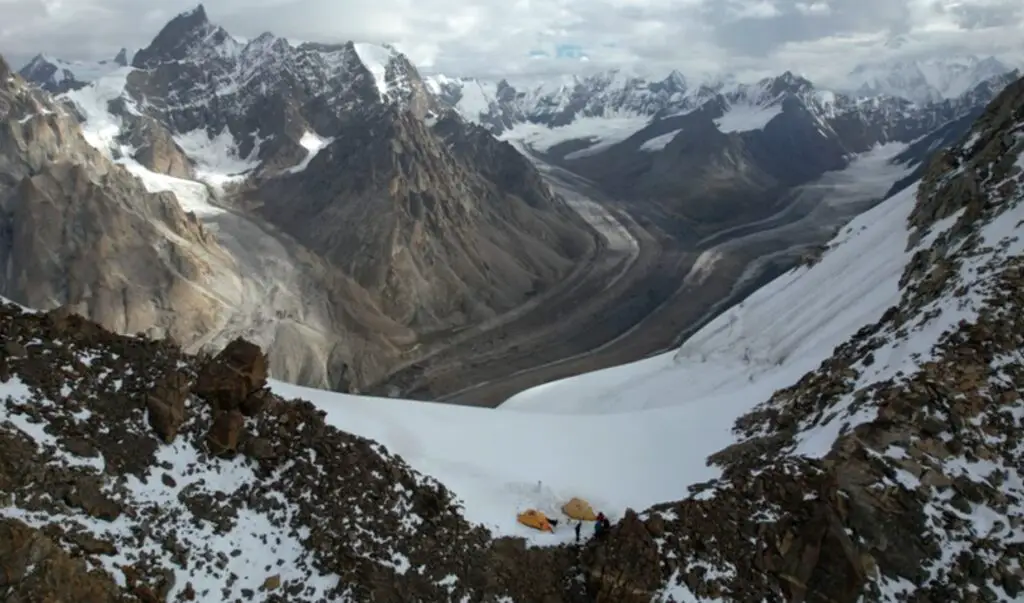
Places to Visit in Gilgit
Beat digital cameras for v-loggers.


Hotel Booking
Visit Gilgit Baltistan is Offering best hotels in town, superbly sited above town and giving views across the valley. The cosy, plush rooms have TV, phone and balcony views. The service is excellent, breakfast is included in the tariff.
Sundus Rent-A-Car
Sundus Rent-A-Car maintains an uncompromising focus on customer service where Quality & Customer comes first. Customer seeks out and stay with Sundus Rent-A-Car because we truly believe in and deliver courteous, personalized service. Our goal is to fulfill our customer’s requirements and delivering them precisely everytime.
Salam Gilgit Baltistan
Salam Gilgit Baltistan has started Daily Toyota Coaster From Rawalpindi to Skardu and Skradu to Rawalpindi
Travel Guide
Gilgit-Baltistan (formerly known as the Federally Administered Northern Areas or FANA ) is the northernmost political entity within Pakistan. According to Pakistan's constitution, Gilgit-Baltistan is a self governing region under Pakistan. Gilgit-Baltistan is home to some of the world's highest mountains, including five of the eight-thousanders. The main focus of attention for many travelers is the world's three highest mountain ranges--the Karakoram, the Himalaya, and the Hindu Kush, with five peaks over 8,000 meters and many peaks over 7,000 meters, and having the largest glaciers in the world (other than those in the polar region). Wild rivers and unique landscapes make this area a "mountain paradise" for mountaineers, trekkers, and tourists.
Feature Tours

Corporate Group Tours

University, Colleges, Study Tours

Honymoon Packages

Couples Packages

Camping, Tracking
Special packages.

Honey Moon Packages
Visit gilgit Baltistan Offering Affordable Tour Packages for Honey Moon.

Couple Packages
Visit Gilgit Baltistan Offering Affordable Tour Packages for Couples.

Family Packages
Visit Gilgit Baltistan Offering Affordable Tour Packages for Family.
- PHOTOGRAPHY
- Date and Words
Project Description
Gilgit baltistan tourist guide map.
Gilgit Baltistan always has a place in my heart because I have started my life’s first journey from Astore Valley in Gilgit Baltistan in 2011. This place made me fall in love with travelling . Gilgit Baltistan is full of hospitality, nature and rich culture. At that time, I did not think that I would make a map of this place after 10 years. G.B map is a bit different from my other guide maps. It’s more detailed and more realistic so people can easily get the guidance from this tourist guide map as we have communication, signal and internet issues in our northern areas of Pakistan. I hope this map is going to help many domestic and international tourists/travellers. Hardcopy of map will be available soon. Drop your message at [email protected].
Attractions
01- Serena Khaplu Palace
02- Masherbrum
04- Kharpocho Fort
05- Manthal Rock
07- Katpana Desert
08- Hussainabad Waterfall Skardu
09- Manthoka Waterfall
10- Deosai Top
11- Deosai Plains
12- Deosai National Park
14- Burzil Pass
15- Nanga Parbat
16- Fairy Meadows
17- Khunjerab Pass
18- Passu Cones Viewpoint
19- Hussaini Suspension Bridge
20- Baltit Fort
21- Altit Fort
22- Eagle Nest View Point
23- Rakaposhi View Point
24- Twin Gilgit Bridge
25- Kargah Buddha, Yshani
26- Shandur National Park
01- Hushe River Valley
02- Saling Valley
03- Bagrot Valley
04- Minimarg Valley
05- Astore Valley
06- Tarishing Valley
07- Parishing Gah Valley
08- Basho Valley
09- Bilamik Valley
10- Shimshal Valley
11- Hunza Valley
12- Hopar Valley
13- Naltar Valley
14- Ishkoman Valley
15- Phander Valley
01- Jarba Zhou Lake
02- Sadpara Lake
03- Sheosar Lake
04- Rainbow Lake
05- Dirle Lake
06- Rama Lake
07- Allah Wali Lake
08- Upper Kachura Lake
09- Lower Kachura Lake
10- Attabad Lake
11- Rush Lake
12- Kacheli Lake
13- Karambar Lake
14- Khalti Lake
15- Baha Chhat Lake
16- Kutwal Lake
17- Kharfak Lake
Related Projects

Kanniyakumari Tourist Guide Map by Assam Artist

Discover Multan Poster Design

Discover Islamabad Poster Design

Discover Karachi Poster Design

Discover Lahore Poster Design
Leave a comment cancel reply.
Basha, Gilgit-Baltistan
Gilgit-Baltistan
Around the Globe
Hurricane tracker, radar & maps, news & features.
Max UV Index 6 High
Wind NNW 5 mph
Wind Gusts 13 mph
Probability of Precipitation 92%
Probability of Thunderstorms 27%
Precipitation 0.45 in
Rain 0.45 in
Hours of Precipitation 3.5
Hours of Rain 3.5
Cloud Cover 92%
Wind Gusts 12 mph
Probability of Precipitation 84%
Probability of Thunderstorms 24%
Precipitation 0.17 in
Rain 0.17 in
Hours of Precipitation 2
Hours of Rain 2
Cloud Cover 83%
Sun & Moon
Temperature history, further ahead.
Top Stories
Severe Weather
Potent storms to rattle, drench central and eastern US
11 hours ago

At least 1 person injured after tornado sweeps through DC suburbs
4 hours ago

Weather Forecasts
Blistering heat wave to roast interior West into second week of June
12 hours ago

Hot air balloon crashes into power lines, injuring 3 people
15 hours ago

A pause on summer temps, humidity as cooler air expands eastward

Featured Stories
Weather News
D-Day anniversary: How the weather forecast changed the tide of war

10 of the hottest cities in the US

Deadly tornadoes tear through South Africa, killing 11

Long path to identifying woman who disappeared in Hurricane Katrina

Octopus changing color steals the show, delights beachgoers

Weather Near Basha:
- Katzarah , Gilgit-Baltistan
- Skardo , Gilgit-Baltistan
- Skardu , Gilgit-Baltistan
We have updated our Privacy Policy and Cookie Policy .
Get AccuWeather alerts as they happen with our browser notifications.
Notifications Enabled
Thanks! We’ll keep you informed.
IMAGES
VIDEO
COMMENTS
Local Transport: Depends on distance, but most transport should cost between 500 and 1,500 PKR between destinations in Gilgit-Baltistan. For longer journeys ( Islamabad and beyond) expect prices to be 1,800 to 3,000 PKR. Jeep Hire: Expect to pay 6,000-7,000 PKR per day for a jeep and driver.
GILGIT- BALTISTAN. Gilgit-Bal stan of Pakistan is endowed with some of the unique geographical features of the world. In an area of about 500 km wide and 350 km deep, is found to be the most lucra ve collec on of some of the highest peaks in the world. It has over 700 peaks above 6000 meters, and more than 108 peaks above 7000 meters including ...
Gilgit-Baltistan (GB) is a very sparsely populated high-mountain area in the north of Pakistan. Its natural environment is usually described with superlatives - the longest glaciers outside of the polar region, home of the world's second highest peak (K2) and four more eight-thousanders. GB is largely a high-mountain desert; geologically ...
Map of Gilgit-Baltistan. Gilgit-Baltistan is large, remote, with 3 administrative divisions. ... This region travel guide to Gilgit-Baltistan is an outline and may need more content. It has a template, but there is not enough information present. If there are Cities and Other destinations listed, ...
Gilgit-Baltistan, formerly known as the Northern Areas is the northernmost political entity under the administrative control of Pakistan. Asia. South Asia. Pakistan. Gilgit-Baltistan ... map to travel: gilgitbaltistan.gov.pk. Wikivoyage. Wikipedia. Photo: Mobeen Saeed, CC BY-SA 4.0. Photo: Wikimedia, CC BY-SA 3.0. Popular Destinations.
By ahmadnaseebs. best time to visit Deosai is mid June to mid september. See ways to experience (9) 3. Altit Fort. 142. Historic Sites. Altit Fort, located in the Hunza Valley of Gilgit-Baltistan, Pakistan, is a historic architectural gem that dates back over 900 years. Perched on a rocky hilltop overlooking the Hunza River, this ….
The area of Gilgit Baltistan is about 72,971 sq km. The people here are very hospitable, and you will find a majority of Shia Muslims with a substantial number of Sunni Muslims, Ismaili, Hindus, and Christians. Gilgit Baltistan is also home to many tourist attractions, such as Shandur Pass and Jaglot.
This map was created by a user. Learn how to create your own. Gilgit-Baltistan. Gilgit-Baltistan. Sign in. Open full screen to view more. This map was created by a user. ...
(Tourism) Gilgit-Baltistan is considered a safe destination for tourists. However, it is recommended to check the travel advisories and take necessary precautions while traveling. It is also advisable to hire a local guide or join a reputable tour operator for a ... Route map of proposed peak/trek
You can visit by jeep to Ghizar district, Chilass city, Astor district, Hunza Valley, Skardu city and Ghanchy from Gilgit. K2, at 8,611 meters the world's 2nd Highest peak, Mashaburam, Gashaburam, Rakaposhi and Nanga Parbat (killer mountain) world's 6th highest peak. You can also visit Fairy meadows. 35.922 74.305.
By Road. The only route to reach Gilgit Baltistan from Islamabad is via the Karakoram Highway. But there are different starting route to take all of which will converge into one at some point. Route 1: via Babusar - Naran - Chilas - Gilgit. Route 2: via Abbotabad - Mansehra - Batgram - Dasu - Chilas - Gilgit.
Astore Valley is a hidden gem in the Gilgit-Baltistan region of Pakistan, nestled among the majestic foothills of the Himalayas. Known for its beautiful landscape, greenish meadows, snow-capped mountains, glistening glaciers, appealing waterfalls, and pristine rivers, this valley offers a truly enthralling experience for nature lovers and adventurers alike.The Valley is located in the eastern ...
Gilgit-Baltistan (/ ˌ ɡ ɪ l ɡ ɪ t ˌ b ɔː l t ɪ ˈ s t ɑː n,-s t æ n /; Urdu: گِلْگِت بَلْتِسْتان listen ⓘ), formerly known as the Northern Areas, is a region administered by Pakistan as an administrative territory and consists of the northern portion of the larger Kashmir region, which has been the subject of a dispute between India and Pakistan since 1947 and ...
For centuries, deadly mountain passes and the highest concentration of 26,000-foot peaks in the world left Gilgit-Baltistan isolated. Unable to rule it directly, various empires tried to govern the region through local leaders, so that as late as 1936, the Kashmir Times noted that one of the most powerful, the Mir of Hunza, still paid "tribute to four governments: British, Chinese, Russian ...
Pakistan. Information. Directory. Map. Gilgit Baltistan is, perhaps, the most spectacular region of Pakistan in terms of its geography and scenic beauty. Here world's three mightiest mountain ranges: the Karakoram, the Handukuch and the Himalayas - meet. The whole of Gilgit Baltistan is like a paradise for mountaineers, trekkers and anglers.
Kalash Valley in Gilgit-Baltistan. Chitral Valley is also home to the Kalash Valleys, where the Kalash tribe resides. Rumbur, Bamburet and Birir are three of the Kalash valleys with Bamburet being the most populated. While Bamburet is 40 kilometres from the city of Chitral via a jeep ride, Rumbur and Birir are 32 and 34 kilometres away ...
Attabad Lake, Hunza. Tourism in Gilgit-Baltistan, an administered territory of Pakistan, focuses on its access to various mountain ranges and alpine terrain. Various tourist destinations attract millions of travelers from within Pakistan. [1] On the other hand, tourists from other countries also routinely visit GB. [2]
50 BEAUTIFUL PLACES TO VISIT IN GILGIT BALTISTAN. Ghizer Valley. Astore Valley, Gilgit
For each location, ViaMichelin city maps allow you to display classic mapping elements (names and types of streets and roads) as well as more detailed information: pedestrian streets, building numbers, one-way streets, administrative buildings, the main local landmarks (town hall, station, post office, theatres, etc.).You can also display car parks in Gilgit, real-time traffic information and ...
Gilgit (/ ˈ ɡ ɪ l ɡ ɪ t /; Shina: گلیٗت; Urdu: گلگت IPA: [ˈɡɪlɡɪt]) is a city in Pakistani-administered Gilgit-Baltistan in the disputed Kashmir region. It is the capital of the Gilgit-Baltistan region. The city is located in a broad valley near the confluence of the Gilgit and the Hunza rivers. It is a major tourist destination in Pakistan, serving as a hub for trekking ...
Travel Guide. Gilgit-Baltistan ... Gilgit-Baltistan is home to some of the world's highest mountains, including five of the eight-thousanders. The main focus of attention for many travelers is the world's three highest mountain ranges--the Karakoram, the Himalaya, and the Hindu Kush, with five peaks over 8,000 meters and many peaks over 7,000 ...
Gilgit-Baltistan Tourist Guide (Android App) Helps tourist who visits Gilgit-Baltistan and its vicinity. It is using customized Google Maps to provide directions, distances and location of...
Gilgit Baltistan always has a place in my heart because I have started my life's first journey from Astore Valley in Gilgit Baltistan in 2011. This place made me fall in love with travelling . Gilgit Baltistan is full of hospitality, nature and rich culture. At that time, I did not think that I would make a map of this place after 10 years.
Everything you need to know about tomorrow's weather in Basha, Gilgit-Baltistan, Pakistan. High/Low, Precipitation Chances, Sunrise/Sunset, and tomorrow's Temperature History.